
Page 14 - Dungeon Master's Guide
P. 14
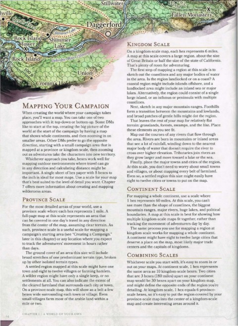
KINGDOM  SCALE
                                                              On a kingdom-scale map, each hex represents 6 miles.
                                                              A map at this scale covers a large region, about the size
                                                              of Great Britain or half the size of the state of California.
                                                              That's plenty of room for adventuring.
                                                               The first step of mapping a region at this scale is to
                                                              sketch out the coastlines and any major bodies of water
                                                              in the area. Is the region landlocked or on a coast? A
                                                              coastal region might include islands offshore, and a
                                                              landlocked area might include an inland sea or major
                                                              lakes. Alternatively, the region could consist of a single
                                                              large island, or an isthmus or peninsula with multiple
                                                              coastlines.
            MAPPING YouR CAMPAIGN                              Next, sketch in any major mountain ranges. Foothills
            When creating the world where your campaign takes   form a transition between the mountains and lowlands,
            place, you'll want a map. You can take one of two   and broad patches of gentle hills might dot the region.
            approaches with it: top-down or bottom-up. Some DMs   That leaves the rest of your map for relatively fiat
            like to start at the top, creating the big picture of the   terrain: grasslands, forests, swamps, and the like. Place
            world at the start of the campaign by having a map   these elements as you see fit.
            that shows whole continents, and then zooming in on   Map out the courses of any rivers that flow through
                                                              the area. Rivers are born in mountains or inland areas
            smaller areas. Other DMs prefer to go the opposite
                                                              that see a lot of rainfall, winding down to the nearest
            direction, starting with a small campaign area that is
            mapped at a province or kingdom scale, then zooming   major body of water that doesn't require the river to
                                                              cross over higher elevation. Tributaries join rivers as
            out as adventures take the characters into new territory.
                                                              they grow larger and move toward a lake or the sea.
             Whichever approach you take, hexes work well for
                                                               Finally, place the major towns and cities of the region.
            mapping outdoor environments where travel can go
                                                              At this scale, you don't need to worry about small towns
            in any direction and calculating distance might be
                                                              and villages, or about mapping every belt of farmland.
            important. A single sheet of hex paper with 5 hexes to
                                                              Even so, a settled region this size might easily have
            the inch is ideal for most maps. Use a scale for your map
                                                              eight to twelve cities or towns to put on the map.
            that's best suited to the level of detail you want. Chapter
            7 offers more information about creating and mapping
                                                              CONTINENT SCALE
            wilderness areas.
                                                              For mapping a whole continent, use a scale where
            PROVINCE  SCALE                                   1 hex represents 60 miles. At this scale, you can't
                                                              see more than the shape of coastlines, the biggest
            For the most detailed areas of your world, use a
                                                              mountain ranges, major rivers, huge lakes, and political
            province scale where each hex represents 1 mile. A
                                                              boundaries. A map at this scale is best for showing how
            full-page map at this scale represents an area that
                                                              multiple kingdom-scale maps fit together, rather than
            can be covered in one day's travel in any direction
                                                              tracking the movement of adventurers day by day.
            from the center of the map, assuming clear terrain. As
                                                               The same process you use for mapping a region at
            such, province scale is a useful scale for mapping a
                                                              kingdom scale works for mapping a whole continent.
            campaign's starting area (see "Creating a Campaign,"
                                                              A continent might have eight to twelve large cities that
            later in this chapter) or any location where you expect
            to track the adventurers' movement in hours rather   deserve a place on the map, most likely major trade
            than days.                           •            centers and the capitals of kingdoms.
             The ground cover of an area this size will include
                                                              COMBINING SCALES
            broad stretches of one predominant terrain type, broken                --~--------------
            up by other isolated terrain types.               Whichever scale you start with, it's easy to zoom in or
             A settled region mapped at this scale might have one   out on your maps. At continent scale, 1 hex represents
            town and eight to twelve villages or farming hamlets.   the same area as 10 kingdom-scale hexes. Two cities
            A wilder region might have only a single keep, or no   that are 3 hexes (180 miles) apart on your continent
            settlements at all. You can also indicate the extent of   map would be 30 hexes apart on your kingdom map,
            the cleared farmland that surrounds each city or town.   and might define the opposite ends of the region you're
            On a province-scale map, this will show as a belt a few   detailing. At kingdom scale, 1 hex equals 6 province-
            hexes wide surrounding each town or village. Even   scale hexes, so it's easy to put the region covered by your
            small villages farm most of the arable land within a   province-scale map into the center of a kingdom-scale
            mile or two.                                      map and create interesting areas around it.
            CHAPTER 1  I A  WORLD  OF YOUR OWN
    I4