
Page 102 - Microsoft Word - Bogra-01-Community-11
P. 102
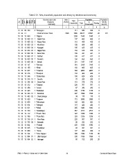
Table C-01 : Area, household, population and density by residence and community

Zila                            Administrative Unit   Area       Total           Population            Population
     Upazila                           Residence     (Acres)  Households
                                        Community                         Total       In     Floating  Density
         UN /                                                                    Households            (sq. km)
             MWZarAd/
                  MAH
                      Village
                           RMO

12                                             3     45                    6     7           8         9
                                                                                                         871
10 33 09 780 2 *Sonjoypur                                          211      936    936           0
                                                     7948 7286            28017  27997         20
10 33 13                        Chamrul Union Total                        5140   5140           0
                                                                  1243                           0
10 33 13 060 1 *Atgaon                                             147      653    653           0
                                                                   110      459    459           0
10 33 13 060 01 1 Dighir Para                                      120      489    489           0
                                                                   105      425    425           0
10 33 13 060 02 1 Khiyar Para                                      150      539    539           0
                                                                   102      341    341           0
10 33 13 060 03 1 Khunihara                                        100      417    417           0
                                                                   158      650    650           0
10 33 13 060 04 1 Kayagari                                         251     1167   1167           0
                                                                   616     2249   2249           0
10 33 13 060 05 1 Nagar Para                                       150      605    605           0
                                                                   583     2203   2203           0
10 33 13 060 06 1 Saha Para                                        133      463    463           0
                                                                   180      629    629           0
10 33 13 060 07 1 Parthiot                                           70     250    250           0
                                                                   110      379    379           0
10 33 13 060 08 1 Poradah                                          228      767    767           0
                                                                     97     393    393           0
10 33 13 060 09 1 Belhali                                          446     1736   1736           0
                                                                   407     1558   1558           0
10 33 13 147 1 *Berunja                                              39     178    178           0
                                                                   712     2696   2696           0
10 33 13 155 1 *Bhali                                              226      882    882           0
                                                                   118      424    424           0
10 33 13 207 1 *Chamrul                                            255     1082   1082           0
                                                                   657     2513   2513           0
10 33 13 276 1 *Daimpur                                            324     1208   1208           0
                                                                   283     1209   1209           0
10 33 13 346 1 *Dobla Para                                         225      957    957           0
                                                                     58     252    252           0
10 33 13 346 01 1 Sanulla                                          435     1580   1580           0
                                                                     93     341    341           0
10 33 13 346 02 1 Dobla Para                                       127      499    499         20
                                                                   380     1398   1378           0
10 33 13 372 1 *Gharam                                             300     1086   1086         20
                                                                     80     312    292
10 33 13 458 1 *Johali

10 33 13 493 1 *Kathahali

10 33 13 493 01 1 Kathahali

10 33 13 493 02 1 Chak Sohaga

10 33 13 553 1 *Kolgram

10 33 13 605 1 *Mamudpur

10 33 13 614 1 *Mangait

10 33 13 631 1 *Matai

10 33 13 700 1 *Mustafapur

10 33 13 752 1 *Panch Thita

10 33 13 795 1 *Pora Para

10 33 13 795 01 1 Pora Para

10 33 13 795 02 1 Bakadah

10 33 13 804 1 *Pothatti

10 33 13 865 1 *Sarabdipur

10 33 13 969 1 *Tema

10 33 13 994 1 *Uttar Sajapur

10 33 13 994 01 1 Uttar Sajapur

10 33 13 994 02 1 Haringari

RMO: 1 = Rural, 2 = Urban and 3 = Other Urban        84                                                Community Report: Bogra