
Page 106 - Microsoft Word - Bogra-01-Community-11
P. 106
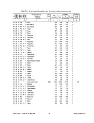
Table C-01 : Area, household, population and density by residence and community

Zila                            Administrative Unit   Area       Total            Population            Population
     Upazila                           Residence     (Acres)  Households
                                        Community                         Total        In     Floating  Density
         UN /                                                                     Households            (sq. km)
             MWZarAd/
                  MAH
                      Village
                           RMO

12                                             3     45                    6      7           8         9
                                                                                                         1209
10 33 54 674 1 *Merai                                              204      780     780           0
                                                                   353     1223    1223           0
10 33 54 709 1 *Bara Nilahali                                      278      966     966           0
                                                                     75     257     257           0
10 33 54 709 01 1 Bara Nilahali                                    257      900     900           0
                                                                   102      388     388           0
10 33 54 709 02 1 Koigari                                          344     1150    1150           0
                                                                   257      847     847           0
10 33 54 718 1 *Nurpur                                               87     303     303           0
                                                                   383     1488    1488           0
10 33 54 735 1 *Palkuri                                            311     1204    1204           0
                                                                     72     284     284           0
10 33 54 744 1 *Panchusha                                          396     1436    1436           0
                                                                   338     1196    1196           0
10 33 54 744 01 1 Panchusha                                          58     240     240           0
                                                                   307     1094    1094           0
10 33 54 744 02 1 Satni                                            213      767     767           0
                                                                     94     327     327           0
10 33 54 761 1 *Paogachha                                          275     1054    1054           0
                                                                     73     244     244           0
10 33 54 761 01 1 Paogachha                                        321     1221    1221           0
                                                                   184      740     740           0
10 33 54 761 02 1 Khoksa Para                                      137      481     481           0
                                                                     92     370     370           0
10 33 54 770 1 *Paota                                              545     2039    2039           0
                                                                   288     1108    1108           0
10 33 54 770 01 1 Paota                                            184      724     724           0
                                                                   104      384     384           0
10 33 54 770 02 1 Damkuri                            5665 7065            27724   27718           6
                                                                   473     1810    1810           0
10 33 54 813 1 *Pukurgachha                                        137      527     527           0
                                                                     75     322     322           0
10 33 54 813 01 1 Pukurgachha                                      120      475     475           0
                                                                   125      428     428           0
10 33 54 813 02 1 Pora Para                                          16                           0
                                                                   407        58      58          0
10 33 54 821 1 *Raghu Bansipur (Hapina)                            144     1563    1563           0
                                                                   505      511     511           6
10 33 54 873 1 *Saram                                              246     1891    1885           0
                                                                            869     869
10 33 54 899 1 *Singra

10 33 54 899 01 1 Singra

10 33 54 899 02 1 Batahar

10 33 54 925 1 *Surjyata

10 33 54 943 1 *Taloch

10 33 54 986 1 *Unahat

10 33 54 986 01 1 Unahat

10 33 54 986 02 1 Chak Manohar

10 33 67                        Talora Union Total

10 33 67 112 1 *Belgharia

10 33 67 112 01 1 Gari Belgharia

10 33 67 112 02 1 Sana Belgharia

10 33 67 112 03 1 Rasulpur

10 33 67 112 04 1 Chak Shola

10 33 67 112 05 1 Chak Gopal

10 33 67 302 1 *Debkhanda

10 33 67 311 1 *Debrason

10 33 67 363 1 *Dubra

10 33 67 363 01 1 Dubra

RMO: 1 = Rural, 2 = Urban and 3 = Other Urban        88                                                 Community Report: Bogra