
Page 105 - Microsoft Word - Bogra-01-Community-11
P. 105
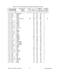
Table C-01 : Area, household, population and density by residence and community

Zila                            Administrative Unit   Area       Total           Population            Population
     Upazila                           Residence     (Acres)  Households
                                        Community                         Total       In     Floating  Density
         UN /                                                                    Households            (sq. km)
             MWZarAd/
                  MAH
                      Village
                           RMO

12                                             3     45                    6     7           8         9
                                                                                                         929
10 33 40 726 1 *Pali Maheshpur                                     229      913    913           0
                                                                   270     1126   1126           0
10 33 40 882 1 *Sarjankuri                                         357     1494   1494           0
                                                                   235      897    897           0
10 33 40 891 1 *Sherpur                              7209 7391            27101  27099           2
                                                                   210      757    757           0
10 33 40 908 1 *Sreepur                                            175      629    629           0
                                                                     35     128    128           0
10 33 54                        Gunahar Union Total                267      986    986           0
                                                                   182      683    683           0
10 33 54 017 1 *Amjhupi                                              35     130    130           0
                                                                     50     173    173           0
10 33 54 017 01 1 Amjhupi                                          186      665    665           0
                                                                   383     1401   1401           0
10 33 54 017 02 1 Baraikuri                                        171      607    607           0
                                                                   163      615    615           0
10 33 54 034 1 *Arjungari                                            49     179    179           0
                                                                   214      741    739           2
10 33 54 034 01 1 Arjungari                                        298     1185   1185           0
                                                                   255      978    978           0
10 33 54 034 02 1 Suhali                                           181      688    688           0
                                                                     74     290    290           0
10 33 54 034 03 1 Khurda Para                                        73     258    258           0
                                                                   148      551    551           0
10 33 54 051 1 *Atail                                                94     359    359           0
                                                                     54     192    192           0
10 33 54 129 1 *Belhatta                                             93     321    321           0
                                                                   590     2107   2107           0
10 33 54 129 01 1 Belhatta                                         410     1468   1468           0
                                                                     85     312    312           0
10 33 54 129 02 1 Singa                                              95     327    327           0
                                                                   123      448    448           0
10 33 54 129 03 1 Kazigari                                         162      565    565           0
                                                                   161      631    631           0
10 33 54 138 1 *Beragaon                                             86     319    319           0
                                                                     30     124    124           0
10 33 54 164 1 *Bhandaria                                            45     188    188           0
                                                                     94     320    320           0
10 33 54 181 1 *Bhatanda                                           194      692    692           0

10 33 54 181 01 1 Bhatanda

10 33 54 181 02 1 Dochia

10 33 54 224 1 *Chandi Mandap

10 33 54 259 1 *Chhota Beragaon

10 33 54 259 01 1 Chhota Beragaon

10 33 54 259 02 1 Dashara

10 33 54 389 1 *Gunahar

10 33 54 415 1 *Jajira

10 33 54 415 01 1 Jajira

10 33 54 415 02 1 Danga Para

10 33 54 415 03 1 Karamji

10 33 54 432 1 *Jarai

10 33 54 484 1 *Kamaru

10 33 54 501 1 *Keut

10 33 54 501 01 1 Keut

10 33 54 501 02 1 Sana Para

10 33 54 501 03 1 Nandar Para

10 33 54 510 1 *Khagra

10 33 54 562 1 *Kurahar

RMO: 1 = Rural, 2 = Urban and 3 = Other Urban        87                                                Community Report: Bogra