
Page 272 - NS-2 Textbook
P. 272
METEOROLOGY 267
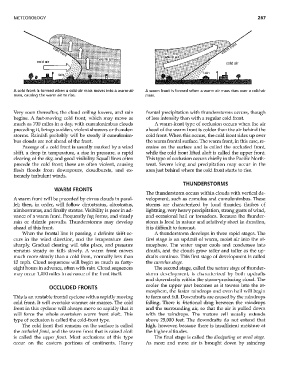
A cold front is formed when a cold-air mass moves into a warm-air A warm front is formed when a warm air mass rises over a cold-air
mass, causing the warm air to rise. mass.
Very soon thereafte,; the cloud ceiling lowers, and rain frontal precipitation with thunderstorms occurs, though
begins. A fast-moving cold front, which may move as of less intensity than with a regular cold front.
much as 700 miles in a day, with cumulonimbus clouds A warm-front type of occlusion occurs ,,\Then the au'
preceding it, brings sudden, violent showers or thunder- ahead of the warm front is colder than the air behind the
storms. Rainfall probably will be steady if cumulonim- cold front. When this occurs, the cold front rides up over
bus clouds are not ahead of the front. the warm frontal slu·face. The "warm front, in this case, re-
Passage of a cold front is usually marked by a wind mains on the surface and is called the occluded front,
shift, a drop in temperature, a rise in pressure, a rapid while the cold front lifted aloft is called the upper front.
clearing of the sky, and good visibility. Squall lines often This type of occlusion occurs chiefly in the Pacific North-
precede the cold front; these are often violent, causing west. Severe icing and precipitation may occur in the
flash floods from downpours, cloudbursts, and ex- area just behind where the cold front starts to rise.
trenlely turbulent ·winds.
THUNDERSTORMS
WARM FRONTS
The thunderstorm occurs within clouds with vertical de-
A warm front will be preceded by cirrus clouds in paral- velopment, such as cumulus and cumulonimbus. These
lel; then! in ordel~ will fallo'w cirrostratus, altostratus, storms are characterized by loud thunde,; flashes of
nimbostratus, and finally stratus. Visibility is poor in ad- lightrring, very heavy precipitation, strong gusts of wind,
vance of a warm front. Frequently fog forms, and steady and occasional hail or tornadoes. Because the thunder-
rain or drizzle prevails. Thunderstorms may develop storm is local in nature and relatively short in duration,
ahead of this front. it is difficult to forecast.
When the frontal line is passing, a definite shift oc- A thunderstorm develops in three rapid stages. The
curs in the ,vind direction, and the tenlperatm'e rises first stage is an updraft of warm, moist air into the at-
sharply. Gradual clearing will take place, and pressure mosphere. The water vapor cools and condenses into
remains steady or falls slowly. A warm front moves clouds, and the clouds grow taller and taller as the up-
much more slowly than a cold front, normally less than drafts continue. This first stage of development is called
15 mph. Cloud sequences will begin as much as forty- the cUlIlulus stage.
eight hours in advance, often with rain. Cloud sequences TI,e second stage, called the lIlature stage of thunder-
may occur 1,000 miles in advance of the front itself. storm development, is characterized by both updrafts
and downdrafts within the storm-producing cloud. The
cooler the upper part becomes as it towers into the at-
OCCLUDED FRONTS
mosphere, the faster raindrops and even hail will begin
This is an unstable frontal cyclone with a rapidly moving to form and fall. Downdrafts are caused by the raindrops
cold front. It will overtake warmer air masses. The cold falling. TI,ere is frictional drag between the raindrops
front in this cyclone will always move so rapidly that it and the smrounding au; so that the air is pulled down
will force the whole overtaken warm front aloft. This with the raindrops. The mature cell usually extends
type of occlusion is called the cold-front type. above 25,000 feet. The downdrafts do not extend that
The cold front that remains on the surface is called high, however, because there is insufficient lnoisture at
the occluded frol1t, and the warm front that is raised aloft the higher altitudes.
is called the upper frol1t. Most occlusions of this type The final stage is called the dissipati/lg or a/lvil stage.
occur on the eastern portions of continents. Heavy As more and more air is brought down by raindrop