
Page 196 - 9 teachers social book 9 @ 2077 ctp_Neat
P. 196
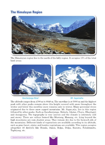
The Himalayan Region


           The Himalayan region lies to the north of the hilly region. It occupies 15% of the total
           land areas.


                       Kanchenjunga Himal                            Mt. Sagarmatha
           The altitude ranges from 4700 m to 8848 m. The snowline is at 5000 m and the highest
           peak with other peaks remain above this height covered with snow throughout the
           winter and below this snowline snow remains only in winter. Many perennial rivers
           originated due to these snow capped mountains. Mt. Sagar,atja, lies in this region
           followed by other peaks. Such as Kanchenjunga, Makalu, Lhotse, Choyu, Dhaulagiri
           and Annapurna. The topography is very uneven and the climate is extremely cold
           and snowy. There are valleys formed like Mustang, Manang, etc. lying beyond the
           high mountains are rain shadow areas. They remain dry due to the leeward side of
           the mountains. Different kinds of vegetations are available according to its altitude,
           such as pine forest, alpine and tundra vegetations are available. This region occupies
           altogether 16  districts  like  Humla,  Jumla,  Rolpa, Dolpa,  Rasuwa,  Solukhumbu,
           Taplejung, etc.


             Dynamic Social Studies - Book IX      196