
Page 215 - 9 teachers social book 9 @ 2077 ctp_Neat
P. 215
Lesson Map Work
6.8
FACTS Everyone required a road map or city map
to Understand whenever he/she is in a new place. With the
help of map there is no chance of getting lost
anywhere. Map is the real guide for new places.
Maps are important for various purposes. So the skill of drawing map is essential.
Map is also called cartography. Cartography is an art and science of representing
like drawing and compiling of geographical area graphically, usually by means of
maps, chart and figures. Map is a flat picture drawn in the piece of paper but it is
very essential for everybody. Map is the diagrammatic, graphic representation of the
earth’s surface. Map is essential in every fields like industry, military, transportation,
communication or engineering.
There are different types of maps. Some of them are discussed below:
i. Topographical Map
The word topography means the landforms of the earth. Topographical maps
are those maps which show all information related to natural as well as cultural
landscape. They include multiple information such as rivers, lakes, mountains, hills,
forest, cultivated area, buildings, roads, village, institutions, etc. Contour lines are
used to show changes in the landscape with the use of different colours and shades.
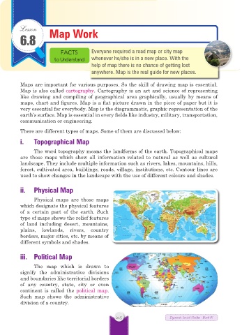
ii. Physical Map
Physical maps are those maps
which designate the physical features
of a certain part of the earth. Such
type of maps shows the relief features
of land including desert, mountains,
plains, lowlands, rivers, country
borders, major cities, etc. by means of
different symbols and shades.
iii. Political Map
The map which is drawn to
signify the administrative divisions
and boundaries like territorial borders
of any country, state, city or even
continent is called the political map.
Such map shows the administrative
division of a country.
215 Dynamic Social Studies - Book IX