
Page 218 - 9 teachers social book 9 @ 2077 ctp_Neat
P. 218
Lesson Knowledge on Distance or Scale
6.9
and Its Uses
FACTS The scale is very important in drawing map because
to Understand it reduces the actual shape and size of an object and
show in a paper.
A scale is a system of units for measuring. It is the series of marks at regular intervals
for the purpose of measuring as we can see on a ruler. Maps are drawn according to
scale in order to show the relative proportions of distance on the map similar to those
on the ground. The scale has a vital role in drawing a map because the actual shape
and size of an object is not possible to show on paper without a scale. A scale can be
represented in three ways which are given below:
1. Representative Scale
It is represented in the form of fraction. It is also called numerical scale. It can
be denoted in double ways through any of the following equations:
1
15000
The numerator of the fraction signified the length on the map and the denominator
indicates the length on the actual ground. Here, the numerator gets divided by the
denominator. For example, or 1:1000 which implies that 1 cm on the map justifies
1000 cm on the earth surface. It does not require mentioning any unit of measurement
such as cm, inches, feet of any other conventional units since both numerator and
denominator are shown and understood in the same unit.
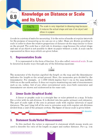
2. Linear Scale (Graphical Scale)
A linear or graphic scale is a straight line or ruler printed on a map. It looks
like a ruler with its sub-division. It is divided into two parts: primary and extension.
The part of scale right of the zero is primary scale with regular intervals of equal
distances. The part lying left of the zero is extension scale with regular sub-divisions
divided from a unit of the primary section. The figure of linear scale is given below:
0 25 50 100 kilometres
3. Statement Scale/Verbal Measurement:
In this method, the ration is expressed in statement which means words are
used to describe the ratio of the length on paper and surface distance. For e.g. 1cm
Dynamic Social Studies - Book IX 218