
Page 184 - DK Children's Encyclopedia
P. 184
Navigation SEE ALSO
▸ ▸ Compass p.70
▸ ▸ Constellations
Navigation is finding where you are and where you are p.73
going. We can use the sun, stars, a compass, and paper ▸ ▸ Light p.147
maps to navigate. Today, most modern transportation ▸ ▸ Maps p.155
receives signals from satellites in space to show where ▸ ▸ Radio p.203
it is on Earth. This is called GPS. ▸ ▸ Satellites p.215
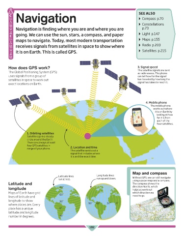
How does GPS work? 3. Signal speed
The Global Positioning System (GPS) The satellite signals are sent
as radio waves. The phone
uses signals from a group of can tell how far the signal
satellites in space to work out has traveled by how long the
exact locations on Earth. signal has taken to reach it.
4. Mobile phone
The mobile phone
works out where
it is on Earth by
looking at how
far it is from
each of the
four satellites.
1. Orbiting satellites
Satellites go in a steady
circle around the Earth.
There are always at least
four GPS satellites in
range of your phone. 2. Location and time
The satellite sends out a
signal that includes where
it is and the exact time.
Map and compass
Latitude lines Longitude lines Without GPS, we can still navigate
run across. run up and down. using a paper map and a compass.
Latitude and The compass shows the
longitude 90˚ direction North, which
helps us work out
Maps of Earth have grid 60˚ which direction we
lines of latitude and need to go.
longitude to show 30˚
where places are. Every 90˚ 60˚ 30˚ 0˚
place has a unique 0˚
latitude and longitude
number in degrees. 30˚
182
US_182_Navigation.indd 182 16/05/2017 09:49