
Page 60 - How It Works - Book of Amazing Answers To Curious Questions, 12
P. 60
AMAZIG ANSWERS TO CURIOUS QUESTIONS
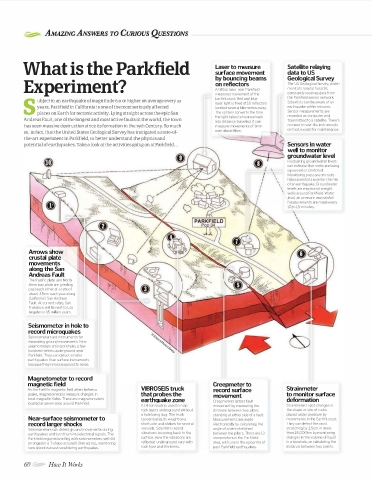
What is the Parl<field surface movement Satellite relaying
Laser to measure
data to US
by bouncing beams Geological Survey
Experiment? A hilltop laser near Parkfield The US Geological Survey, which
on reflectors
monitors natural hazards,
measures movement of the constantly receives data from
Earth's crust. Red and blue the Parkfield sensor network.
ubject to an earthquake of magnitude 6.o or higher on average every 22 Scientists can be aware of an
laser light is fired at 18 reflectors
years, Parkfield in California is one of the most seriously affected located several kilometres away. earthquake within minutes.
S places on Earth for tectonic activity. Lying straight across the epic San The system converts the time Sensor measurements are
the light takes to bounce back recorded on computer and
Andreas Fault, one of the longest and most active faults in the world, the town into distance travelled. It can transmitted to a satellite. There's
has seen massive destruction since its formation in the 19th Century. So much no need to visit the instruments
on foot, except for maintenance.
so, in fact, that the United States Geological Survey has instigated a state-of
the-art experiment in Parkfield, to better understand the physics and
potential of earthquakes. Take a look at the activities going on at Parkfield ... Sensors in water
well to monitor
groundwater level
Fluctuating groundwater levels
can indicate that rocks are being
\ squeezed or stretched.
\ Monitoring pressure on rocks
\
\ helps scientists monitor the risk
\ of an earthquake. Groundwater
\
\ levels are monitored in eight
\
wells around Parkfield. Water
level, air pressure and rainfall
measurements are made every
10 to 15 minutes.
Arrows show
crustal plate
movements
along the San
Andreas Fault
The Pacific plate and North
American plate are grinding
past each other at a rate of
about 3.5cm each year along
California's San Andreas
Fault. At current rates, San
Francisco will lie next to Los
Angeles in 15 million years.
Seismometer in hole to
record microquakes
Seismometers are instruments for
measuring ground movements. Nine
seismometers sit in boreholes a few
hundred metres underground near
Parkfield. They can detect smaller
earthquakes than surface instruments
because they're less exposed to noise.
Magnetometer to record
magnetic field Creepmeter to
As the Earth's magnetic field alters before a VIBROSEIS truck record surface Strain meter
quake, magnetometers measure changes in that probes the movement to monitor surface
local magnetic fields. There are magnetometers earthquake zone deformation
located at seven sites around Parkfield. Creepmeters detect fault
A 14·ton truck is used to map movement by measuring the Strainmeters spot changes in
rock layers underground without distance between two pillars the shape or size of rocks
a hole being dug. The truck standing at either side of a fault. placed under pressure by
Near-surface seismometer to concentrates its weight on a Measurements are made movements in the Earth's crust.
record larger shocks short pole and shakes for several electronically by calculating the They can detect the crust
Seismometers can detect ground movements during seconds. Scientists record angle of a wire stretched stretching by 2.5cm in more
earthquakes and turn them into electrical signals. The vibrations bouncing back to the between the pillars. There are 13 than 25,000km by monitoring
Parkfield region is bristling with seismometers, with 14 surface. How the vibrations are creepmeters in the Parkfield changes in the volume of liquid
arranged in a T-shape around l-2km across, monitoring reflected underground vary with area, with one in the epicentre of in a borehole, or calculating the
how shock waves travel during earthquakes. rock type and thickness. past Parkfield earthquakes. distance between two points.
60 How It TtOrks WorldMags.net
WorldMags.net