
Page 64 - How It Works - Book of Amazing Answers To Curious Questions, 12
P. 64
AMAZIG ANSWERS TO CURIOUS QUESTIONS -------------------
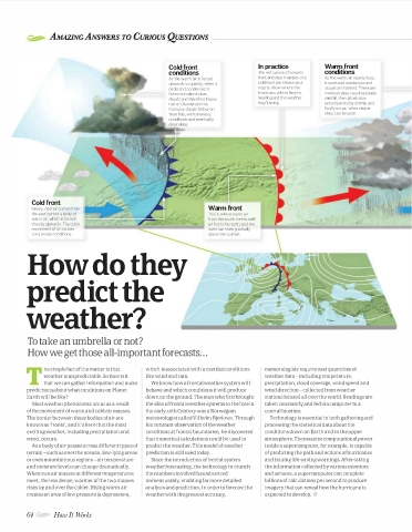
Cold front In practice Warm front
conditions The red curves of a warm conditions
As the warm air is forced front and blue triangles of a As the warm air slowly rises,
upwards so quickly, when it cold front are shown on a it cools and condenses and
cools and condenses it map to show where the clouds are formed. These are
forms cumulonimbus fronts are, where they're nimbostratus, causing steady
clouds and therefore heavy heading and the weather rainfall, then altostratus
rain or thunderstorms. they'll bring. accompanied by drizzle, and
Cumulus clouds follow on finally cirrus, when clearer
skies can be seen.
Cold front
Heavy, cool air comes from Warm front
the east behind a body of This is where warm air
warm air, which is forced from the south meets cold
sharply upwards. The quick air from the north, and the
movement of air causes warm air rises gradually
cool, windy conditions. above the cold air.
How do they
predict the
weather?
To take an umbrella or not?
How we get those all-important forecasts ...
he simple fact of the matter is that which is associated with unsettled conditions meteorologists require vast quantities of
weather is unpredictable. So how is it like wind and rain. weather data -including temperature,
T that we can gather information and make We know how a frontal weather system will precipitation, cloud coverage, wind speed and
predictionsaboutwhat conditions on Planet behave and which conditions it will produce wind direction -collected from weather
Earth will be like? down on the ground. The man who first brought stations located all over the world. Readings are
Most weather phenomena occur as a result the idea of frontal weather systems to the fore in taken constantly and fed via computer to a
of the movement of warm and cold air masses. the early 2oth Century was a Norwegian central location.
The border between these bodies of air are meteorologist called Vi! helm Bjerknes. Through Technology is essential to both gathering and
known as 'fronts', and it's here that the most his constant observation of the weather processing the statistical data about the
exciting weather, including precipitation and conditions at frontal boundaries, he discovered conditions down on Earth and in the upper
wind, occurs. that numerical calculations could be used to atmosphere. The massive computational power
As a body of air passes across different types of predict the weather. This model of weather inside a supercomputer, for example, is capable
terrain -such as over the oceans, low-lying areas prediction is still used today. of predicting the path and actions of hurricanes
or even mountainous regions -air temperature Since the introduction of frontal system and issuing life-saving warnings. After taking
and moisture levels can change dramatically. weather forecasting, the technology to crunch the information collected by various monitors
When two air masses at different temperatures the numbers involved has advanced and sensors, a supercomputer can complete
meet, the less dense, warmer of the two masses immeasurably, enabling far more detailed billions of calculations per second to produce
rises up and over the colder. Rising warm air analysis and prediction. In order to forecastthe imagery that can reveal how the hurricane is
creates an area of low pressure Ia depression), weather with the greatest accuracy, expected to develop.
64 How It TtOrks WorldMags.net
WorldMags.net