
Page 158 - (DK Eyewitness) Travel Guide - Southwest USA & National Parks
P. 158
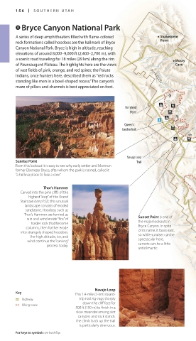
156 SOUTHERN UT AH SOUTHERN UT AH 157
e Bryce Canyon National Park Bryce Amphitheater VISITORS’ CHECKLIST
This panoramic vista of
A series of deep amphitheaters filled with flame-colored Shakespear snow-covered rock Practical Information
rock formations called hoodoos are the hallmark of Bryce Point spires is among the most Road map B2. Hwy 63 off Hwy
popular views of the
Canyon National Park. Bryce is high in altitude, reaching park. In both winter and 12. n Bryce Canyon National
Park, P.O. Box 170001, UT 84717–
elevations of around 8,000–9,000 ft (2,400–2,700 m), with summer the amphitheater 0001, (435) 834-5322. Open year
a scenic road traveling for 18 miles (29 km) along the rim Mossy is best seen from round, daily. Visitor center
of Paunsaugunt Plateau. The highlights here are the views Cave Inspiration Point. Open Apr & Oct: 8am–6pm;
of vast fields of pink, orange, and red spires; the Paiute May–Sep: 8am–8pm; Nov–Mar:
8am–4:30pm. Closed Jan 1,
Indians, once hunters here, described them as “red rocks Pink Cliffs Thanksgiving, Dec 25. & 7
standing like men in a bowl-shaped recess.” The canyon’s not public hols. 8 0 =
maze of pillars and channels is best appreciated on foot. ∑ nps.gov/brca
Transport
~ Bryce Canyon Airport. @ mid-
J
Apr–late-Oct: shuttles make regular
Fairyland runs from Rudy’s Inn and Camp-
Point ground to the park entrance, and
from the park entrance to Bryce
Point, with many stops in between.
J
Queen’s
Garden Trail JJ
Bryce
J
J Natural Bridge
Point This graceful natural bridge is
located a few yards from the
Paria park’s scenic highway. It frames
View a picturesque view of the distant
Navajo Loop valley far below. Officially, it is a
Pink Cliffs
Sunrise Point Trail natural arch and not a bridge, as
From this lookout it is easy to see why early settler and Mormon Pink Cliffs it was formed not by a river but
farmer Ebenezer Bryce, after whom the park is named, called it by the same natural forces (of wind,
“a helluva place to lose a cow.” rain, and ice) that created the
park’s hoodoos.
Thor’s Hammer
Carved into the pink cliffs of the Agua Canyon
highest “step” of the Grand This overlook features some
Staircase (see p152), this unusual Swamp of the most delicate and
landscape consists of eroded Canyon beautiful of the park’s
sandstone. Hoodoos such as Butte formations, as well as a good
Thor’s Hammer are formed as view of the layered pink
rain and wind erode “fins” of Sunset Point is one of Noon sandstone cliffs typical of
harder rock that become the major lookouts in Canyon the Paunsaugunt Plateau.
columns, then further erode Bryce Canyon. In spite Butte
into strangely shaped hoodoos. of its name, it faces east,
The high altitude, ice, and so while sunrises can be
wind continue the “carving” spectacular here,
process today. sunsets can be a little J
anticlimactic.
Rainbow
Point
J
J J
J
Ponderosa
Navajo Loop
Key This 1.4-mile (2-km) round- Canyon Yovimba
Highway trip trail zig-zags sharply Point
down the cliff face for Utah Prairie Dog
Hiking route
500 ft (150 m) to finish in a Now threatened, the Utah
slow meander among slot prairie dog lives only in
canyons and rock stands. 0 km 2 Pink Cliffs southern Utah: those living in
The climb back up the trail 0 miles 2 the park today constitute the
is particularly strenuous. largest remaining group.
For keys to symbols see back flap For hotels and restaurants see pp240–41 and pp254–6
156-157_EW_SW_USA.indd 156 28/11/17 12:41 PM 156-157_EW_SW_USA.indd 157 28/11/17 12:41 PM