
Page 160 - (DK Eyewitness) Travel Guide - Southwest USA & National Parks
P. 160
158 SOUTHERN UT AH SOUTHERN UT AH 159
t Zion National Park Numerous guided walking and VISITORS’ CHECKLIST
Hiking Tours
hiking tours of Zion’s geology
Zion Canyon lies at the heart of this national park and is and history leave daily from the Practical Information
arguably the most popular of all of Utah’s natural wonders. visitor center. Popular trails are Road map 2B. Hwy 9, near
The canyon was carved by the Virgin River and then widened, Emerald Pools Trail, and Canyon Spring dale. n Zion Canyon
Visitor Center (435) 772-3256.
sculpted, and reshaped by wind, rain, and ice. The canyon Overlook Trail, which leads to a Open 8am–5pm daily (to 7pm
walls rise up to 2,000 ft (610 m) on both sides, and are shaped superb west-facing viewpoint Jun–Aug; to 6pm Sep). & 7
over the canyon.
into jagged peaks and formations in shades of red and white. partial. 8 - = 0
Although you can drive through the park year-round, from ∑ nps.gov/zion
mid-March to late-November the only way to explore the
inner core of Zion Canyon is via the park’s frequent shuttle Horseback Tours
buses. Numerous stops along the way offer access to hiking One-hour- and half-hour-long Sculpted monoliths of rock
trails; some lead to nearby waterfalls and alcoves, while horseback tours follow trails in the rise above the Virgin River as it
park. The Sandbench Trail leads to a
flows along the canyon.
others, like the demanding East and West Rim trails, climb high plateau that offers fine vistas.
right out of the canyon. There is limited parking space, so
visitors are advised to park in Springdale and take the free
shuttle to the park.
River Walk
At the end of Zion Canyon
Scenic Drive lies the park’s
most popular trail. Involving
no climbing, the 1.3-mile
(2-km) paved River Walk
follows the Virgin River to
where the canyon walls rise
to over 2,000 ft (600 m). The
trail offers beautiful views of
the river as it winds between Weeping Rock
red sandstone walls. An easy, self-guided trail leads to
the rock and its hanging gardens,
which are full of wild flowers in
spring. This spot owes its fertility
Exploring Zion Canyon to the spring- and seep-water that
Once inside the park, the 6-mile (10-km) Scenic Drive follows flows from the rock.
the Virgin River into the ever-narrowing canyon. From spring
through fall, shuttle buses
operate both along the
drive and between the
visitor center and the
nearby town of Springdale. Luxuriant foliage along the
banks of the Virgin River
provides shade for the area’s
Key Weeping abundant wildlife, including
Rock birds, mule deer, and bobcats.
Highway
Hiking trail
Emerald Zion Canyon
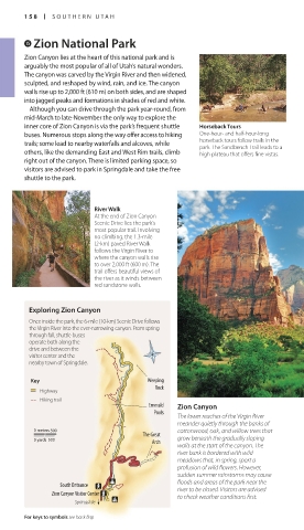
Pools The Virgin River seems
The lower reaches of the Virgin River
meander quietly through the banks of gentle, but the force of its
current is responsible for
0 meters 500 cottonwood, oak, and willow trees that forming the canyon.
The Great
0 yards 500 Arch grow beneath the gradually sloping
walls at the start of the canyon. The
river bank is bordered with wild Zion–Mt. Carmel Highway
meadows that, in spring, sport a The only driving route through the
park, the dramatic Zion–Mt. Carmel
profusion of wild flowers. However, highway climbs out of the canyon via a
sudden summer rainstorms may cause set of hairpin switchbacks with splendid
floods and areas of the park near the
South Entrance views, then burrows through a mile-
Zion Canyon Visitor Center river to be closed. Visitors are advised long tunnel (permit required for large
to check weather conditions first.
Springdale vehicles) to reach the pastel-colored
sandstone of the surrounding peaks.
For keys to symbols see back flap For hotels and restaurants see pp240–41 and pp254–6
158-159_EW_SW_USA.indd 158 28/11/17 12:41 PM 158-159_EW_SW_USA.indd 159 28/11/17 12:41 PM