Page 159 - (DK Eyewitness) Travel Guide - Southwest USA & National Parks
P. 159

SOUTHERN  UT AH      157


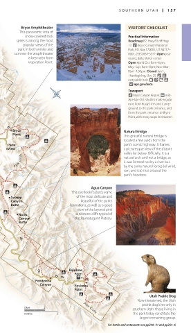
         Bryce Amphitheater                      VISITORS’ CHECKLIST
        This panoramic vista of
          snow-covered rock                      Practical Information
       spires is among the most                  Road map B2. Hwy 63 off Hwy
          popular views of the                   12. n Bryce Canyon National
        park. In both winter and                 Park, P.O. Box 170001, UT 84717–
      summer the amphitheater                    0001, (435) 834-5322. Open year
            is best seen from                    round, daily. Visitor center
            Inspiration Point.                   Open Apr & Oct: 8am–6pm;
                                                 May–Sep: 8am–8pm; Nov–Mar:
                                                 8am–4:30pm. Closed Jan 1,
                                                 Thanksgiving, Dec 25. & 7
                                                 not public hols. 8 0 = 
                                                  ∑ nps.gov/brca
                                                 Transport
                                                 ~ Bryce Canyon Airport. @ mid-
                                                 Apr–late-Oct: shuttles make regular
                                                 runs from Rudy’s Inn and Camp-
                                                 ground to the park entrance, and
                                                 from the park entrance to Bryce
                                                 Point, with many stops in between.
   J
      Bryce
 J                                             Natural Bridge
      Point                                    This graceful natural bridge is
                                               located a few yards from the
    Paria                                      park’s scenic highway. It frames
    View                                       a picturesque view of the distant
                                               valley far below. Officially, it is a
       Pink Cliffs                             natural arch and not a bridge, as
                                               it was formed not by a river but
                                               by the same natural forces (of wind,
                                               rain, and ice) that created the
                                               park’s hoodoos.
                                   Agua Canyon
                            This overlook features some
     Swamp                   of the most delicate and
     Canyon                    beautiful of the park’s
     Butte                 formations, as well as a good
                              view of the layered pink
        Noon                 sandstone cliffs typical of
        Canyon               the Paunsaugunt Plateau.
        Butte


        J


                           Rainbow
                             Point
               J
                     J J
                                 J
              Ponderosa
                Canyon       Yovimba
                             Point
                                                        Utah Prairie Dog
                                                    Now threatened, the Utah
                                                      prairie dog lives only in
          0 km   2              Pink Cliffs       southern Utah: those living in
          0 miles     2                           the park today constitute the
                                                     largest remaining group.
                                         For hotels and restaurants see pp240–41 and pp254–6

   156-157_EW_SW_USA.indd   157                             28/11/17   12:41 PM
   154   155   156   157   158   159   160   161   162   163   164