
Page 164 - (DK Eyewitness) Travel Guide - Southwest USA & National Parks
P. 164
162 THE FOUR C ORNERS INTRODUCING THE FOUR C ORNERS 163
Introducing the Four Corners Getting Around
A car is essential for getting around the Four Corners; a
The Four Corners region is the only place in the United States high-clearance 4WD vehicle is recommended for traveling
where four states meet at a single point. Here, parts of Utah, many interesting, unpaved regional roads. Secondary THE FOUR CORNERS
Colorado, Arizona, and New Mexico make up an area of (paved) highways are generally good, while unpaved
roads are categorized as follows: good roads are suitable
national monuments and parks, ancient ruins, and dramatic for all passenger cars; high-clearance roads are suitable
canyonlands, many set on Native American reservations. for 2 or 4WD vehicles; 4WD roads should be tackled by
World-famous vistas include the buttes of Monument Valley, only experienced drivers in high-clearance vehicles.
and Colorado’s San Juan Skyway, where both the highway Always check on road and weather conditions.
and the Durango-Silverton Narrow Gauge Railroad travel
through picturesque old alpine towns.
The Keet Seel ruins at the Navajo National
Monument in Arizona
OurayOuray
Key
MonticelloMonticello TellurideTelluride
Mount WilsonMount Wilson Major road
4342m4342m
SilvertonSilverton Minor road
State border
BlandingBlanding COLORADO Windom PeakWindom Peak Summit
COLORADO ElectraElectra
LakeLake 4292m4292m
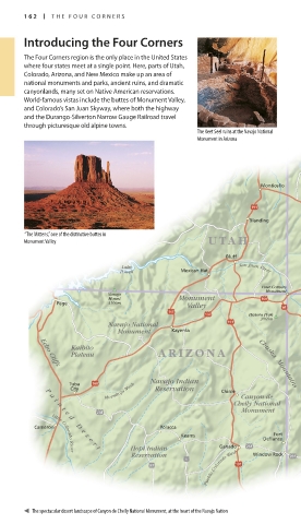
“The Mittens,” one of the distinctive buttes in HesperusHesperus
Monument Valley UTAHUTAH MountainMountain
4033m4033m
CortezCortez VallecitoVallecito
BluffBluff MancosMancos ReservoirReservoir
LakeLake San Juan River DurangoDurango
PowellPowell Mexican HatMexican Hat
San Juan River
Ute Mountain
Ute Mountain
Indian Reservation
Indian Reservation Mesa VerdeMesa Verde
Four Corners NationalNational
Four Corners
Monument ParkPark 0 kilometers
Monument
NavajoNavajo 50
MountMount MonumentMonument
PagePage 3166m3166m ValleyValley NavajoNavajo 0 miles 50
LakeLake
Pastora PeakPastora Peak ShiprockShiprock AztecAztec
2869m2869m KirtlandKirtland
Navajo National Navajo National
MonumentMonument KayentaKayenta Ship RockShip Rock FarmingtonFarmington BloomfieldBloomfield
2188m2188m
KaibitoKaibito ARIZONAARIZONA
PlateauPlateau
HuerfanoHuerfano
MountainMountain
Echo Cliffs
Echo Cliffs
2278m2278m
NEW MEXICONEW MEXICO
Navajo IndianNavajo Indian
TubaTuba
Moenkopi Wash
Chuska Mountains
Chuska Mountains
CityCity ReservationReservation ChacoChaco
P
P Moenkopi Wash ChinleChinle
a Canyon de Canyon de CultureCulture CounselorCounselor
a
i i
Chelly National Chelly National NationalNational
n
n
t t MonumentMonument HistoricHistoric
e
e
ParkPark
d
d
CameronCameron D PolaccaPolacca TohatchiTohatchi
D
e
e FortFort
s
s KeamsKeams
e DefianceDefiance
e
r
r GanadoGanado
Hopi IndianHopi Indian
t t
Pueblo Colorado Wash
Pueblo Colorado Wash
ReservationReservation Window RockWindow Rock GamercoGamerco
Little Colorado River
Little Colorado River
Mountain view on the San Juan Skyway
between Durango and Silverton
The spectacular desert landscape of Canyon de Chelly National Monument, at the heart of the Navajo Nation For keys to symbols see back flap For hotels and restaurants see p241 and pp256–7
162-163_EW_SW_USA.indd 162 28/11/17 1:00 PM 162-163_EW_SW_USA.indd 163 28/11/17 1:00 PM
Eyewitness Travel LAYERS PRINTED:
Explorer template “UK” LAYER
(Source v1.4)
Date 5th December 2012
Size 125mm x 217mm