
Page 217 - (DK Eyewitness) Travel Guide 2017 - Alaska
P. 217
SOUTHWEST ALASK A 215
Mount Ballyhoo
1,634 ft Ferry Dock
AMAKNAK VISITORS’ CHECKLIST
BALLY HOO R O A D Practical Information
ISLAND
850 miles (1,368 km) SW of
Dutch
Harbo r Kodiak. Transport map B5.
* 4,400. n 5 Broadway Ave,
T UNDRA ROAD
Unalaska; 581-2612, (877) 581-
Aleutian World War II 2612. Permits: needed to camp
National Historical Park
or hike on Unalaska and Amaknak
Islands, which are available
Unalaska
Bay DUTCH from the Ounalashka Native
HARBOR Corporation in Dutch Harbor.
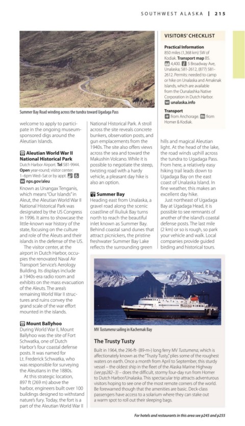
AIRPOR T BEACH R OAD BI O R KA D R E POINT ROA D Summer Bay Summer Bay Road winding across the tundra toward Ugadaga Pass Transport
∑ unalaska.info
1 mile (2 km)
~ from Anchorage. g from
Ounalaska Native Corporation
pate in the ongoing museum-
across the site reveals concrete
Museum of the Aleutians welcome to apply to partici- National Historical Park. A stroll Homer & Kodiak.
Iliuliuk Iliuliuk Bay S U M M E R B AY R O A D sponsored digs around the bun kers, observation posts, and
Harbor
Church of the Aleutian Islands. gun emplacements from the hills and magi cal Aleutian
Holy Ascension 1940s. The site also offers views light. At the head of the lake,
Bunker Hill Small Boat Harbor UNALASKA B AY V I E W R O A D
421 ft P Aleutian World War II across the sea and toward the the road winds uphill across
Library
HENRY S WA N SO N DRIVE Iliuliuk National Historical Park Makushin Volcano. While it is the tundra to Ugadaga Pass.
Captain’s Clinic BROAD W AY RD Dutch Harbor Airport. Tel 581-9944. possible to negoti ate the steep, From here, a relatively easy
Open year-round; visitor center:
Bay South CAPTAIN’S BAY RD Unalaska twisting road with a hardy hiking trail leads down to
Channel Lake 1–6pm Wed–Sat or by appt. & 7 vehicle, a pleas ant day hike is Ugadaga Bay on the east
∑ nps.gov/aleu
Known as Unangax Tenganis, also an option. coast of Unalaska Island. In
fine weather, this makes an
which means “Our Islands” in } Summer Bay excellent day hike.
Aleut, the Aleutian World War II Heading east from Unalaska, a Just northeast of Ugadaga
National Historical Park was gravel road along the scenic Bay at Ugadaga Head, it is
designated by the US Congress coastline of Iliuliuk Bay turns possible to see remnants of
in 1996. It aims to showcase the north to reach the beautiful another of the island’s coastal
little-known war history of the inlet known as Summer Bay. defense posts. The last mile
state, focus ing on the culture Behind coastal sand dunes that (2 km) or so is rough, so park
and role of the Aleuts and their attract picnickers, the pristine your vehicle and walk. Local
islands in the defense of the US. freshwater Summer Bay Lake companies provide guided
The visitor center, at the reflects the sur rounding green birding and historical tours.
airport in Dutch Harbor, occu-
pies the renovated Naval Air
Transport Service’s Aerology
Building. Its displays include
a 1940s-era radio room and
exhibits on the mass evacua tion
of the Aleuts. The area’s
remaining World War II struc-
tures and ruins convey the
grand scale of the war effort
mounted in the islands.
P Mount Ballyhoo
During World War II, Mount MV Tustumena sailing in Kachemak Bay
Ballyhoo was the site of Fort
Schwatka, one of Dutch The Trusty Tusty
Harbor’s four coastal defense Built in 1964, the 296-ft- (89-m-) long ferry MV Tustumena, which is
posts. It was named for affectionately known as the “Trusty Tusty,” plies some of the roughest
Lt. Frederick Schwatka, who waters on earth. Once a month from April to September, this sturdy
was responsible for surveying vessel – the oldest ship in the fleet of the Alaska Marine Highway
the Aleutians in the 1880s. (see pp282–3) – does the difficult, stormy four-day run from Homer
At this strategic location, to Dutch Harbor/Unalaska. This spectacular trip attracts adventurous
897 ft (269 m) above the visitors hoping to see one of the most remote corners of the world.
har bor, engineers built over 100 Be forewarned though that the amenities are basic. Deck-class
buildings designed to with stand passengers have access to a solarium where they can stake out
nature’s fury. Today, the fort is a a warm spot to roll out their sleeping bags.
part of the Aleutian World War II
For hotels and restaurants in this area see p245 and p255
214-215_EW_Alaska.indd 215 02/05/17 2:32 pm