
Page 458 - (DK) Ocean - The Definitive Visual Guide
P. 458
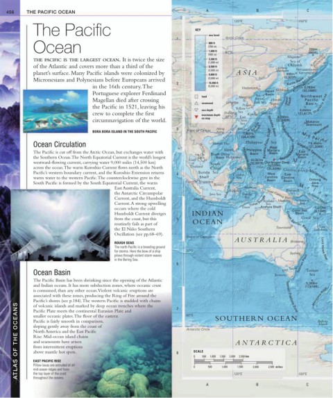
456 THE PACIFIC OCEAN A B C
120ºE 150ºE
The Pacific KEY
1 sea level Arctic Circle
Ocean (250 m) 295m
800 ft
1,600 ft
(500 m) 60ºN (968ft)
Magadan
THE PACIFIC IS THE LARGEST OCEAN. It is twice the size 3,300 ft Kamchatka
(1,000 m) Sea of Peninsula
of the Atlantic and covers more than a third of the 6,500 ft Ostrov Okhotsk
(2,000 m) Sakhalin Petropavlovsk-
planet’s surface. Many Pacific islands were colonized by 9,800 ft ASIA 890m Kamchatskiy
Kurile Basin
Micronesians and Polynesians before Europeans arrived (3,000 m) Amur (2,920ft)
2 16,400 ft Kurile Islands
in the 16th century. The (5,000 m) Vladivostok Kurile Trench
9,783m
Japan Hokkaido (32,098ft)
Portuguese explorer Ferdinand Basin
land Namp’o Sea of Northwest
Magellan died after crossing Japan/ Honshu Japan Pacific
seamount Qingdao East Sea Toyko Trench (21,817ft) Shatskiy Rise
Basin
Pusan
the Pacific in 1521, leaving his Yellow
sea depth 6,650m
crew to complete the first maximum depth Shanghai Sea Kyushu Shikoku
East
30ºN
9,780m
circumnavigation of the world. on map China (32,088ft) Makarov
Sea Seamount
Taiwan Strait (24,476ft) Bonin Trench M i d - P a c i fi c
3 Hong Taiwan Ryukyu Trench Shikoku Basin Mapmaker
Kyushu-Palau Ridge
BORA BORA ISLAND IN THE SOUTH PACIFIC Tropic of Cancer Kong
7,460m
Ocean Circulation Hainan Dao Philippine Sea (21,208ft)
6,464m
West
Manila Philippine Mariana
The Pacific is cut off from the Arctic Ocean, but exchanges water with Basin East
Mekong
Ho Chi South China Basin Mariana
the Southern Ocean. The North Equatorial Current is the world’s longest Gulf Minh Basin Philippines 10,057m Basin
westward-flowing current, carrying water 9,000 miles (14,500 km) of South Philippine Trench Mariana Trench Magellan Seamounts
(32,997ft) Challenger Deep
10,920m
M i c r o n e
across the ocean. The warm Kuroshio Current flows north as the North Thailand China Davao Palau (35,829ft) Caroline Islands
Pacific’s western boundary current, and the Kuroshio Extension returns 4 Sunda Sea Celebes West East
warm water to the western Pacific. The counterclockwise gyre in the Shelf Sea Caroline Caroline Melanesian
Ontong
Basin
South Pacific is formed by the South Equatorial Current, the warm Equator Singapore Basin Java
Borneo M Rise
East Australia Current, Sumatra Makassar Strait Moluccas Bismarck e l
Celebes
the Antarctic Circumpolar Java Sea Banda New Guinea Sea a n
Current, and the Humboldt Jakarta Sea Timor Trough Arafura Moresby Solomon Solomon Islands
Port
Current. A strong upwelling Java Sea Sea
1,577m
occurs where the cold Timor Arafura Shelf Coral Sea (5,174ft)
Humboldt Current diverges INDIAN Basin
Coral Sea
from the coast, but this 5 Great Barrier Reef
routinely fails as part of OCEAN
New
the El Niño Southern Townsville Caledonia
Oscillation (see pp.68–69).
Tropic of Capricorn
A USTRALIA
ROUGH SEAS Brisbane
The north Pacific is a breeding ground Lord Howe Rise
for storms. Here the bow of a ship 30ºS Sydney
plows through violent storm waves
in the Bering Sea.
6 Tasman Plain
Bass Strait Tasman
Ocean Basin Tasmania Sea
The Pacific Basin has been shrinking since the opening of the Atlantic
5,369m
and Indian oceans. It has more subduction zones, where oceanic crust (17,616ft)
is consumed, than any other ocean. Violent volcanic eruptions are
associated with these zones, producing the Ring of Fire around the Tasman Fracture Zone Macquarie Ridge
Pacific’s shores (see p.184). The western Pacific is studded with chains 7 60ºS SOUTHERN OCEAN
ATLAS OF THE OCEANS Pacific is fairly smooth in comparison, 8 Antarctic Circle 1,000 1,500 2,000 ANT ARCTICA Balleny
of volcanic islands and marked by deep ocean trenches where the
Pacific Plate meets the continental Eurasian Plate and
smaller oceanic plates. The floor of the eastern
Islands
sloping gently away from the coast of
North America and the East Pacific
Rise. Mid-ocean island chains
and seamounts have arisen
from intermittent eruptions
SCALE
above mantle hot spots.
0
2,500 km
500
EAST PACIFIC RISE
Pillow lavas are extruded at all
1,500
0
mid-ocean ridges and form
the top layer of the crust
throughout the oceans.
A 500 1,000 120ºE 2,000 2,500 miles 150ºE C
B