
Page 453 - (DK) Ocean - The Definitive Visual Guide
P. 453
THE JAVA TRENCH 451
The Java Trench INDIAN OCEAN F2 thought to lie in the continental
shelf sediments beneath the sea, and
IN THE EASTERN INDIAN OCEAN, the South Equatorial Timor Sea exploitation rights are disputed
between Australia and East Timor.
Current carries water from east to west during the southwest AREA 235,000 square miles (610,000 square km) The warm shallow tropical waters
make the Timor Sea a breeding
monsoon, but shifts south during the northeast monsoon to be MAXIMUM DEPTH 10,800 ft (3,300 m)
INFLOWS Indian Ocean, Arafura Sea ground for tropical storms and
replaced by the eastward-flowing Equatorial Counter Current. cyclones from January to March.
The area includes the deepest part of the Indian Ocean, the Java The Timor Sea marks the eastward Such storms proceed southwestward
boundary of the central Indian Ocean. into the Indian Ocean, sometimes
Trench, where the Australian Plate meets the Eurasian Plate.
Pacific water flows in from the Arafura turning inland to hit the coast of
Sea (see p.473) during the southwest Western Australia. There are fishing
south and west of the trench shows monsoon, feeding the South grounds, including a shrimp fishery,
INDIAN OCEAN D2
tectonic features aligned in Equatorial Current. This flow in coastal waters on the Australian
Java Trench this northerly direction. Between is reversed during the northeast side of the Timor Sea.
Investigator Ridge and Ninetyeast monsoon. Australia’s
LENGTH 1,600 miles (2,600 km) Ridge lie a series of north–south aboriginal people probably
MAXIMUM DEPTH 23,377 ft (7,125 m) fractures formed to accommodate arrived from southeast Asia
different rates of motion in the by island-hopping across
RATE OF CLOSURE 2 / 2 in (6 cm) per year
1
Australian and Indian plates. The the Timor Sea. It is mainly
The Java Trench is a continuation of Ninetyeast Ridge itself is the longest shallow, but with the deep
the Sunda Trench, where the oceanic underwater mountain chain, at 3,100 Timor Trough lying along
part of the Australian Plate is being miles (5,000 km) in length. It followed its northern edge. Significant
subducted beneath the continental in the wake of India’s rapid motion reserves of oil and gas are
Eurasian Plate. A string of volcanoes north as the Indian Ocean opened up.
has resulted behind the trench, strung The ridge represents piles of extruded TIMOR FISHERMEN
out across Sumatra, Java, and the Lesser volcanic material formed above the Traditional, shore-based fishing is
Sunda Islands. The Australian Plate is Kerguelen Hotspot, and were carried practiced by Timorese fishermen,
moving north at a rate of 2 /2 in (6 cm) north as the sea floor spread between seen here hauling in a net at Areia
1
per year. The Indian Ocean floor India and Antarctica. Branca Beach near Dili.
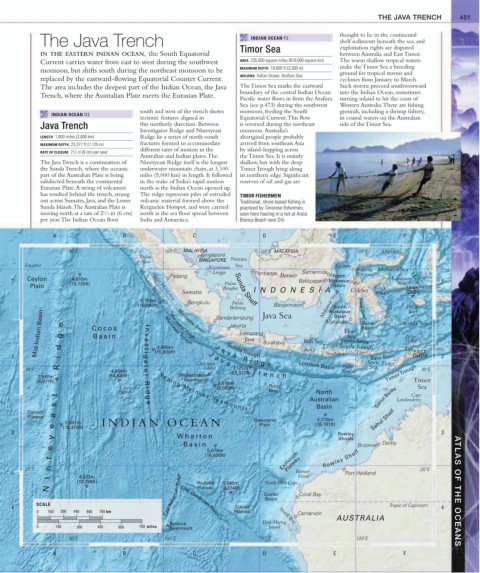
A B C D E F
90˚E 100˚E MALAYSIA 110˚E MALAYSIA 120˚E Manado
Pulau Singapore Natuna
Nias SINGAPORE
Equator Sea
Kepulauan Equator Gulf of Molucca Sea
Lingga Pontianak Samarinda Tomini
Padang Borneo North
4,610m
1 Ceylon (15,125ft) Pulau Balikpapan Makassar Palu Kepulauan Moluccas 1
Sula
Plain Kepulauan Mentawai Bangka Sunda Shelf Basin Teluk 164m
Sumatra INDONESIA Celebes Tolo (538ft)
5,759m Bengkulu Pulau
Selat Mentawai
(18,895ft) Banjarmasin Makassar Strait
South
Belitung Java Sea Makassar Teluk Bone Pulau
Buru
Mid-Indian Basin Cocos n v e Mentawai Trough Jakarta Java Surabaya Bali Sea Makassar Sea Basin Banda Sea
Basin
Bandarlampung
Bone
Ninteyeast Ridge
I
Flores
Mentawai Basin
Semarang
Basin
Pulau
Mentawai Ridge
Wetar
Flores Basin
4,846m
Flores
EAST
Sumbawa
t i
Sunda Trough
2 s (15,900ft) J J a v a R i d g e Bali Lesser Sunda Islands Savu Basin Dili TIMOR 2
Christmas a v a Lombok Basin Savu Timor
g a
10˚S Island 7,125m Pulau Sea 10˚S
4,464m t o r Sumba
1,517m (14,646ft) Shcherbakov (23,377ft) T r e n c h Timor Trough
(4,977ft) Seamount Timor
2,619m
Cocos R i (8,593ft) Roo Sea
Islands d Ve n i n g M e i n e s z S e a m o u n t s Rise North Cape
Australian Sahul Banks Londonderry
Basin
g e
Osborn
Plateau 5,718m Sahul Shelf
5,887m INDIAN OCEAN Gascoyne (18,761ft)
Plain
(19,315ft)
3 Rowley 3
Whar ton
Shoals
Basin Broome Derby
5,678m
Exmouth Rowley Shelf
(18,636ft)
Plateau
20˚S Barrow Port Hedland 20˚S
East Indiaman Ridge Cuvier Coral Bay ATLAS OF THE OCEANS
4,023m Island
(13,199ft) Wallaby (8,334ft) North West Cape
3,540m
Plateau
Basin
SCALE Lost Dutchmen Ridge Tropic of Capricorn
4 Cuvier 4
0 150 300 450 600 750 km Plateau Carnarvon
AUSTRALIA
Batavia Dirk Hartog
Shark Bay
0 150 300 450 600 750 miles Seamount Island
90˚E 100˚E 110˚E 120˚E
A B C D E F