Page 462 - (DK) Ocean - The Definitive Visual Guide
P. 462

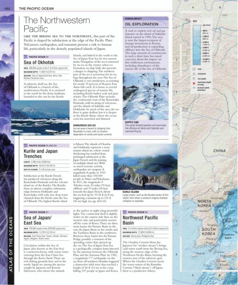
460     THE PACIFIC OCEAN                                                                                        A               B

                                                                                                                                      120˚E
               The Northwestern                                             HUMAN IMPACT                        60˚N  KEY
                                                                            OIL EXPLORATION                                sea level
               Pacific                                                       A rush to exploit rich oil and gas   1         800 ft
                                                                            deposits on the island of Sakhalin             (250 m)
               LIKE THE BERING SEA TO THE NORTHEAST, this part of the       Island started in 1996. The area               1,600 ft
               Pacific is shaped by subduction at the edge of the Pacific Plate.   is now the largest recipient of         (500 m)
                                                                                                                           3,300 ft
               Volcanoes, earthquakes, and tsunamis present a risk to human    foreign investment in Russia,               (1,000 m)
                                                                            and oil production is expanding
                                                                                                                           6,500 ft
               life, particularly in the densely populated islands of Japan.  offshore into the Sea of Okhotsk.            (2,000 m)
                                                                            The large amount of construction               9,800 ft
                                             Islands, and linked in the south to the
                  PACIFIC OCEAN E4                                          in such a short time has raised                (3,000 m)
                                             Sea of Japan/East Sea by two narrow   concerns about the impact on    2       16,400 ft
               Sea of Okhotsk                straits. Navigation of the sea is restricted   this wilderness environment,   (5,000 m)
                                             by sea ice in the winter, when ice   including disturbance of the
               AREA  600,000 square miles (1.6 million square km)  formation on ship hulls also presents    marine life of the Sea of Okhotsk.  land
               MAXIMUM DEPTH  11,063 ft (3,372 m)  a danger to shipping. The southern
                                             part of the sea is notorious for its sea                                   seamount
               INFLOWS  Sea of Japan/East Sea; Amur, Uda,
               Okhota, Penzhina rivers       fogs throughout the year. The Sea of                                       sea depth
                                             Okhotsk is very productive, accounting                                     maximum depth
               A subarctic shelf sea, the Sea    for nearly 70 percent of Russia’s East                                 on map
               of Okhotsk is a branch of the   Asian fish catch. It is home to several                                  tectonic plate
               northwestern Pacific. It is enclosed    endangered species of marine life,                               boundary
               to the north by the Asian landmass,   including Kurile harbor seals and gray                3
               bounded to the east by the Kurile   whales. The Okhotsk Plate includes
                                             the continental crust of the Kamchatka
                                             Peninsula, with its string of volcanoes,
                                             and the islands of Sakhalin and
                                             Hokkaido. In much of the area, the sea                           50˚N
                                             floor is quite shallow, but it is deeper
                                             in the Kurile Basin, where the ocean
                                             crust has stretched and thinned.
                                                                            SUPPLY LINE
                                             DANGEROUS SEA ICE              This partly finished pipeline will eventually   4
                                             Ice can pose a hazard to shipping from   link offshore oil fields with Sakhalin and
                                             November to June, with its location    mainland Russia.
                                             dependent on winds and ocean currents.


                                             is Atlasov. The islands of Honshu
                  PACIFIC OCEAN F5 AND E8
                                             and Hokkaido represent a more
               Kurile and Japan              mature island arc, where crustal                                                    CHINA
                                             thickening has resulted from
               Trenches                      prolonged subduction at the
                                             Japan Trench and the joining
               LENGTH  2,390 miles (3,850 km)
                                             of multiple island arcs. With
               MAXIMUM DEPTH  26,575 ft (8,100 m)  so much tectonic activity,
               RATE OF CLOSURE  3 in (8 cm) per year  earthquakes are rampant. A
                                             magnitude-8 quake in 1923
               Subduction at the Kurile Trench    killed more than 100,000
               has produced volcanoes along the   people in Tokyo and Yokohama.
               Kamchatka Peninsula and the volcanic   In 2011, the magnitude-9
               island arc of the Kuriles. The Kuriles   Tohoku event, 43 miles (70 km)                                                  Tumen
               form an almost complete submarine   offshore and 19 miles (30 km)
               ridge between Hokkaido and    beneath the Japan Trench, thrust   KURILE ISLAND                                           3,276m
               Kamchatka, with only two deep water   the sea bed up by 19-26 ft (6-8 m),   Large craters, such as the flooded center of this   40˚N  (10,749ft)
               channels from the Pacific into the Sea   triggering a tsunami up to 131 ft    island, form when a volcano’s magma chamber   Kimch’aek
               of Okhotsk. The highest Kurile island   (40 m) high (see pp. 462-63).   collapses or explodes.           NORTH
                                                                                                                        KOREA    Hungnam
                                             to the surface at night using powerful                                     Wonsan
                  PACIFIC OCEAN C7                                            PACIFIC OCEAN G6
                                             lights. The continental shelf is slightly   Northwest Pacific   7               Tonghae  Korean Plateau  (69ft)
               Sea of Japan/
                                             wider on the eastern side than on the
        ATLAS OF THE OCEANS  MAXIMUM DEPTH  12,276 ft (3,743 m)  east, the Japan Basin in the north, and   MAXIMUM DEPTH  21,800 ft (6,650 m)  8  Cheju-do  Pusan  Tsushima Basin
                                                                                                                                         21m
                                             western side, and particularly narrow
               East Sea
                                                                           Basin
                                             off the coast of Korea. There are three
                                             main basins: the Yamato Basin in the
                                                                           AREA  2.4 million square miles (6.3 million square km)
               AREA  378,000 square miles (978,000 square km)
                                                                                                                          SOUTH
                                             the Tsushima Basin in the southwest.
                                                                                                                          KOREA
                                                                                                                                      Tsushima
                                             Between these basins lies the Yamato
               INFLOWS  East China Sea; Tumen, Ishikari, Shinano,
                                                                           INFLOWS  Bering Sea, Philippine Sea
               Agano, Mogami, Teshio rivers
                                                                                                                             P’ohang
                                             Ridge, possibly a remnant of the
                                                                           The Oyashio Current (from the
                                             spreading center that opened up
                                                                                                                               Korea Strait
                                             the sea. The Sea of Japan/East Sea
                                                                           Japanese for “mother stream”) brings
               Circulation within the Sea of
                                             is a geologically complex basin bisected
               Japan (also known as the East Sea)
                                                                           cold water south from the Bering Sea,
               is counterclockwise, with warm water
                                             by the junction between the Okhotsk
                                                                           along the western edge of the
                                             Plate and the Eurasian Plate. In 1983,
               entering from the East China Sea
                                                                           Northwest Pacific Basin, forming the
                                                                                                                                     Kitakyushu
                                             a magnitude-7.7 earthquake on the
               through the Korea Strait. There are
                                                                           western arm of the subarctic gyre.
               rich fishing grounds here and in the
                                                                           Where the Oyashio Current meets
                                             sea floor off northern Honshu triggered
               north. Squid are among the species
                                                                                                                                     Kyushu
                                             a destructive tidal wave that reached a
                                                                           the warm waters of the Kuroshio
                                             height of 46 ft (14 m) at the coast,
               sought by Japanese and Korean
                                                                           Current (“black stream”) off Japan,
                                                                                                                                   130˚E
                                                                           there is a productive fishery.
               fishermen, who attract the animals
                                             killing 107 people in Japan and Korea.
                                                                                                                                     B
                                                                                                                    A              Fukuoka
   457   458   459   460   461   462   463   464   465   466   467