Page 461 - (DK) Ocean - The Definitive Visual Guide
P. 461

459


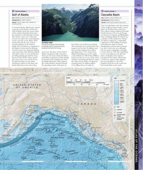
                PACIFIC OCEAN I3                                                                         PACIFIC OCEAN L4
             Gulf of Alaska                                                                           Cascadia Basin

             AREA  600,000 sq. miles (1.5 million sq. km)                                             AREA  66,000 sq. miles (170,000 sq. km)
             MAXIMUM DEPTH  16,400 ft (5,000 m)                                                       MAXIMUM DEPTH  9,600 ft (2,930 m)
             INFLOWS  Susitna, Copper rivers; icebergs from                                           INFLOWS  Pacific Ocean; Columbia, Fraser rivers
             numerous glaciers
                                                                                                      The Cascadia Basin is the last remnant
             A counterclockwise subpolar gyre extends                                                 of the original eastern Pacific oceanic
             across the north Pacific and into the                                                    plate, the Farallon Plate, which has
             Gulf of Alaska, fed by the warm waters                                                   been almost entirely subducted beneath
             of the northern Kuroshio Extension,                                                      North America. The Cascade Range
             the extension of the Kuroshio Current.                                                   of volcanoes in Oregon and Washington
             The surface waters are cooled and                                                        State, including Mount St. Helens, are
             become less saline due to precipitation                                                  a product of this subduction. Mount
             as they cross the ocean. Many of the                                                     St. Helens erupted in a catastrophic
             storms that lash the west coast of   ALASKAN FJORD                                       explosion in 1982, killing 57 people,
             Canada originate in the Gulf of   The valleys and fjords of the Alexander   Fuca Plate west of  Vancouver Island.   and still shows signs of activity.
             Alaska. The circulation is completed as   Archipelago testify to extensive erosion    The seamounts were created above the   Earthquakes and associated tsunamis
             the Alaska Current and the Aleutian   by glaciers during the last ice age.  hotspot over the last 30 million years,   are also a risk in the area, although
             Current return west along the Alaskan                      then carried northwest by seafloor   the last major earthquake is thought
             coast and south of the Aleutian Islands.   were born. The floor of the Gulf of   spreading. Since 1977, oil has been   to have been in 1700. The underlying
             The gulf’s waters are very productive,   Alaska is peppered with seamounts.   shipped through ports on the south   ocean crust appears to be split into
             providing feeding grounds for many   There are two main chains: the Patton   coast of Alaska. In 1989, Prince William   three small plates. The largest is
             species of fish. Pacific salmon spend   and Gilbert seamounts, and the Kodiak   Sound was the site of one of the worst   the Juan de Fuca Plate, named after
             up to five years at sea, much of it in   Seamounts, both running away from   maritime environmental disasters, when  a Greek sea captain who explored
             the gulf and adjacent seas, before   the Alaska Peninsula. Their origin is   the tanker Exxon Valdez ran aground,   the area for Spain in 1592. The
             returning to spawn in the Asian and   the Cobb Hotspot, situated beneath   releasing about 30 million gallons   Explorer Plate lies to the north and
             North American rivers where they   the spreading center of the Juan de   (114 million liters) of crude oil.  the Gorda Plate to the south.


           G                     H                     I                    J                     K                     L

     160˚W            150˚W       Arctic Circle  140˚W              130˚W                     120˚W                        110˚W
                                                                   SCALE                                           KEY
                                                                   0   100  200  300  400  500 km                        sea level
                                                                                                                         800 ft
              UNITED S T A TES                                     0      100     200    300     400     500  miles      (250 m)    1
                 OF AMERICA
                                                                                                                         1,600 ft
      Yukon River                                                                                          60˚N          (500 m)
                                                                                                                         3,300 ft
                                                                                                                         (1,000 m)
                                                                                                                         6,500 ft
                                                                                                                         (2,000 m)
            Kuskokwim River                                                                                              (3,000 m)
                                                                                                                         9,800 ft
                                                                                                                         16,400 ft
                                                                                                                         (5,000 m)
                               Anchorage                                      CANAD A                                               2
                                          Cordova                                                                     land
                            Kenai
                             Peninsula
                                                                                                                      seamount
                         Cook Inlet  Homer  Seward  William  Cape  Yakutat Glacier  Chichagof  Admiralty              sea depth
                                                                           Juneau
                                        Prince
                                              Saint Elias
                                        Sound
                                                                                                                      maximum depth
                                                              Bay
                                                                                                                      on map
                                                                           Island
                                     295m
                                                                          Sitka
                                                                                                                      boundary
                          Shuyak  Portlock Bank  (968ft)  Gulf of Alaska 3,640m  Island Baranof                       tectonic plate
                           Island
        Alaska Peninsula  Kodiak                   Seamount                                 Prince Rupert
      Cape                                                  (11,943ft)  Island        Ketchikan
    Constantine   Shelikof Strait  Kodiak                         Alexander Archipelago  Prince of
                                                     Pratt
    Bristol                             Gulf of Alaska Seamount Province         Wales
                                              Quinn
     Bay                 Island      Giacomini  Seamount  Durgin                 Island Dixon                                       3
                                                                                    Entrance
                                     Seamount
                                                          Seamount
                                                                                Cape
                                               Surveyor
                                               Seamount
                                                               Seamounts
                                                            Welker  Kodiak  Dickins  Knox  Hecate Strait 213m
                                                                         Seamount
    Port Moller                                            Seamount  Denson                  (699ft)                         50˚N
           A l e u t i a n  Tr e n c h  Seamount  Seamount                       Seamount     QueenCharlotte     Strait of Georgia
                               Patton
       Shumagin               Seamount  Patton     Alaska Plain     Seamount  Bowie  Queen Charlotte Islands  Cape
        Islands                     Seamounts      Miller                  Seamount           St.James
                                                                                                 Sound
                                                                                 Oshawa
                                                                                                                       Vancouver
                                     Murray
                                                                                                    Cape
                               Gilbert
                                                   Seamount
                             Seamount              White Marsh                                      Scott  Vancouver Island              ATLAS OF THE OCEANS
                                                                                                                     Victoria
                                                                                                               Strait of
                           Parker                                                                             Juan de Fuca  Seattle  4
                        Seamount                                   Schoppe Ridge                Explorer
                                      Gibson                                                   Seamount
                                     Seamount                          Peters Ridge                                        UNITED
                                                                                                                          STATES OF
                                        G i l b e r t   S e a m o u n t s
                      5,267m                           766m                                                 Cascadia      AMERICA
                      (17,281ft)                       (2,513ft)
      160˚W                     150˚W                           140˚W                             130˚W       Basin
           G                     H                     I                    J                     K                     L
   456   457   458   459   460   461   462   463   464   465   466