
Page 188 - (DK Eyewitness) Travel Guide - Rome
P. 188
186 ROME AREA B Y AREA
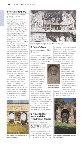
7 Porta Maggiore
Piazza di Porta Maggiore. Map 6 F5.
@ 105. v 3, 5, 14, 19.
Originally the two arches of
Porta Maggiore were not part
of the city wall, but part of an
aqueduct built by the Emperor
Claudius in AD 52. They carried
the water of the Aqua Claudia
over the Via Labicana and Via
Prenestina, two of ancient
Rome’s main southbound roads.
You can still see the original
roadway beneath the gate. In
the large slabs of basalt – a hard
volcanic rock used in all old Relief showing breadmaking on the tomb of the baker Eurysaces
Roman roads – note the great
ruts created by centuries of 8 Baker’s Tomb (see p177). It was later extended
cart wheel traffic. On top of the Piazzale Labicano. Map 6 F5. @ 105. to the Imperial residences on
arches, separate conduits carried v 3, 5, 14, 19. the Palatine. Partly incorporated
the water of two aqueducts: the into later buildings, the impos
Aqua Claudia, and its offshoot, In the middle of the streetcar ing arches make their way via
the Aqueduct of Nero. They intersection near Porta Maggiore the Lateran to the Celian hill.
bear inscriptions from the time stands the tomb of the rich baker Along the first section of the
of the Emperor Claudius and Eurysaces and his wife Atistia, aqueduct, in Via Statilia, is a
also from the reigns of Vespasian built in 30 BC. Roman small tomb in the
and Titus, who restored them in custom forbade shape of a house,
AD 71 and AD 81, respectively. burials within city walls, dating from the
In all, six aqueducts from and the roads leading 1st century BC,
different water sources entered out of cities became bearing the names
the city at Porta Maggiore. lined with tombs and like nesses of a
The Aqua Claudia was and monuments for group of freed slaves.
43 miles (68 km) long, with the middle and upper Their name, Statilii,
over 9 miles (15 km) above classes. This tomb is indicates that they
ground. Its majestic arches shaped like a baking had been freed by the
are a notable feature of the oven: a lowrelief Statilii, the family of
Roman countryside, and a frieze at the top Relief on the Tomb of Claudius’s notorious
popular mineral water bears its shows Eurysaces the Statilii freedmen wife Messalina.
name. One stretch of the Aqua presiding over his Servants of families
Claudia had its arches bricked slaves in the various phases of often pooled funds in this way
up when it was incorporated breadmaking. The inscription to pay for a dignified burial in a
into the 3rdcentury Aurelian proudly asserts his origins, and common resting place.
Wall (see p198). reveals him as a freed slave,
probably of Greek origin. Many
men like him saved money from
their meager slave salaries to
earn their freedom and set up
businesses, becoming the
backbone of Rome’s economy.
9 Aqueduct of
Nero and the
Freedmen’s Tombs
Intersection of Via Statilia and
Via di Santa Croce in Gerusalemme.
Map 10 D1. @ 105, 649. v 3, 5, 14, 19.
Open by appt only: call 060608.
The aqueduct was built by Nero
in the 1st century AD as an
Porta Maggiore, a city gate formed by the extension of the Aqua Claudia Well-preserved section of Nero’s Aqueduct
arches of an aqueduct to supply Nero’s Golden House near San Giovanni
US_186-187_EW_Rome_US.indd 186 15/03/17 4:20 pm
Eyewitness Travel LAYERS PRINTED:
Catalogue template “UK” LAYER
(Source v1.9)
Date 20th August 2012
Size 125mm x 217mm