
Page 112 - Inventions - A Visual Encyclopedia (DK - Smithsonian)
P. 112
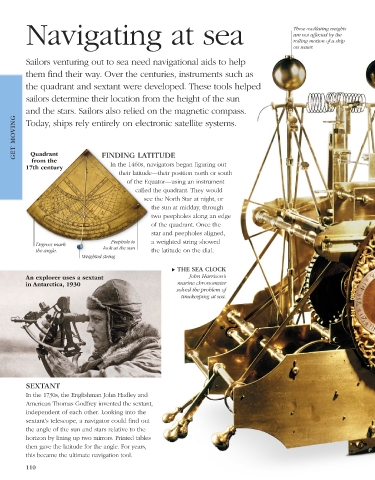
Navigating at sea                                                                      These oscillating weights
                                                                                                 are not affected by the
                                                                                                 rolling motion of a ship
                                                                                                 on water.

          Sailors venturing out to sea need navigational aids to help
          them find their way. Over the centuries, instruments such as

          the quadrant and sextant were developed. These tools helped
          sailors determine their location from the height of the sun

          and the stars. Sailors also relied on the magnetic compass.
      GET MOVING
          Today, ships rely entirely on electronic satellite systems.


           Quadrant
           from the               FINDING LATITUDE
         17th century                In the 1460s, navigators began figuring out
                                        their latitude—their position north or south
                                          of the Equator—using an instrument
                                             called the quadrant. They would
                                                see the North Star at night, or
                                                  the sun at midday, through
                                                  two peepholes along an edge
                                                  of the quadrant. Once the
                                                  star and peepholes aligned,
                                     Peephole to    a weighted string showed
             Degrees mark          look at the sun
             the angle.                           the latitude on the dial.
                            Weighted string
                                                         ▶ THE SEA CLOCK
         An explorer uses a sextant                            John Harrison’s
         in Antarctica, 1930                               marine chronometer
                                                           solved the problem of
                                                            timekeeping at sea.


          SEXTANT
          In the 1730s, the Englishman John Hadley and
          American Thomas Godfrey invented the sextant,
          independent of each other. Looking into the
          sextant’s telescope, a navigator could find out
          the angle of the sun and stars relative to the
          horizon by lining up two mirrors. Printed tables
          then gave the latitude for the angle. For years,
          this became the ultimate navigation tool.
          110


   US_110-111_Navigating_at_sea_Main.indd   110                                                                  08/03/18   3:09 PM