
Page 59 - (DK Eyewitness) Travel Guide - Hungary
P. 59
BUD APEST AREA B Y AREA 57
CASTLE DISTRICT
The hill town of Buda grew up around its castle evolution of Buda but it was neglected under
and Mátyás Church from the 13th cen tury Turkish rule and then destroyed by Christian
onwards. The hill’s fine strategic position, troops. Under the Habs burgs, the town was
at 60 m (197 ft) above the Danube, and its reborn, however, and assumed an important
natural resources made it a prize site. In role during the 18th and 19th centuries. By
the 13th century, a large settle ment arose the end of World War II, the old town had
when King Béla IV decided to build his own been almost utterly destroyed and the Royal
defensive castle and establish his capital here. Palace burned to the ground. Since the war,
The reign of King Mátyás Corvinus in the both the district and the palace have been
15th century was an important period in the restored to their former glory.
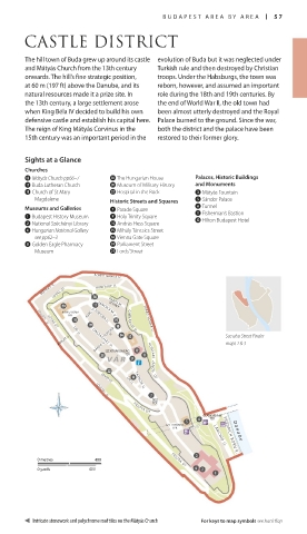
Sights at a Glance
Churches
w Mátyás Church pp66–7 0 The Hungarian House Palaces, Historic Buildings
u Buda Lutheran Church p Museum of Military History and Monuments
i Church of St Mary s Hospital in the Rock 3 Mátyás Fountain
Magdalene Historic Streets and Squares 5 Sándor Palace
Museums and Galleries 7 Parade Square 6 Tunnel
1 Budapest History Museum 9 Holy Trinity Square q Fisherman’s Bastion
e Hilton Budapest Hotel
2 National Széchényi Library r András Hess Square
4 Hungarian National Gallery t Mihály Táncsics Street
see pp62–3 y Vienna Gate Square
8 Golden Eagle Pharmacy o Parliament Street
Museum a Lords’ Street
SZABÓ ILONKA U.
MÁTRAY U. LOVAS ÚT HUNFALVY U.
BABITS M.
SÉTANY
KAPISZTRÁN KARD U. TÁNCSICS M. U.
TÉR FORTUNA U. GIMN ÁZ I U M U . SZABÓ ILONKA U.
LOGODI U.
FORTUNA K. See also Street Finder
LOVAS ÚT
ÚRI U.
KORLÁT U. maps 1 & 3
ORSZÁGH
DÁRDA U. ÁZ U.
SZENTHÁROMSÁG
TÉR
VÁ R HUNYADI JÁNO S Ú T
LOVAS ÚT
ÚRI U.
TÁRNOK U.
LOGODI U.
DÍSZ
TÉR
PALOTA ÚT
TÉR
SZT. GYÖRGY
TÉR CLARK ÁDÁM FRIEDRICH BORN R.
D a n u b e
LÁNCHÍD U.
0 metres 400 PALOTA ÚT
0 yards 400
Intricate stonework and polychrome roof tiles on the Mátyás Church For keys to map symbols see back flap
Hun_056-057_Area-intro.indd 57 17/02/2015 12:58