
Page 551 - (DK Eyewitness) Travel Guide - Spain
P. 551
THE C ANAR Y ISLANDS 549
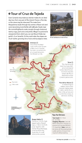
i Tour of Cruz de Tejeda
Gran Canaria’s mountainous interior makes for an ideal
day tour, from any part of the island. Choose a fine day
or the views may be obscured. The route from
Maspalomas leads through dry ravines of bare rock and
cacti, becoming more fertile with altitude. Roads near
the central highlands snake steeply through shattered,
tawny crags, past caves and pretty villages to panoramic
viewpoints from which you can see Mount Teide (see
pp542–3) on Tenerife. On the north side, the slopes are White farmhouses en route to Teror
much lusher, growing citrus fruits and eucalyptus trees.
Artenara 2
One of the inhabited Las Palmas
caves in this town houses
a little church. Another
has been converted into
an unusual restaurant,
the Mirador La Cilla. Valleseco
J Lanzarote
Teror 1
This charming old
J
town has many well-
• preserved, typical
Pinar de Cuevas Canary Island houses.
Tamadaba J Corcho Its church, Nuestra
Señora del Pino, is
dedicated to Gran
Canaria’s patron saint.
Key
J
Tour route Pico de las Nieves 4
Other roads Tejeda A meteorological
station crowns Gran
Canaria’s highest peak.
At 1,949 m (6,395 ft), it is
often chilly up here and
it sometimes snows, so
take extra clothing.
J J Telde
0 kilometres 2 Ayacata J
0 miles 1
Maspalomas
Tips for Drivers
Tour length: 35–45 km
Roque Nublo 3 (22–28 miles).
This 60-m- (195-ft-) high Stopping-off points: Cueva del
jagged spike of basalt Molino restaurant in Artenara is a
tops a 1,700-m (5,578-ft) popular lunch spot (tel 928 66 62
peak. To gether with 27, closed Mon). Note: roads can
nearby Roque Bentayga, be narrow with few passing places;
it was sacred to the sudden patches of cloud or mist
Guanches. It’s a stiff may loom without warning.
climb to the summit.
For keys to symbols see back flap
548-549_EW_Spain.indd 549 26/09/17 11:03 am