
Page 233 - (DK Eyewitness) Travel Guide - India
P. 233
CENTR AL INDIA 231
MADHYA PRADESH &
CHHATTISGARH
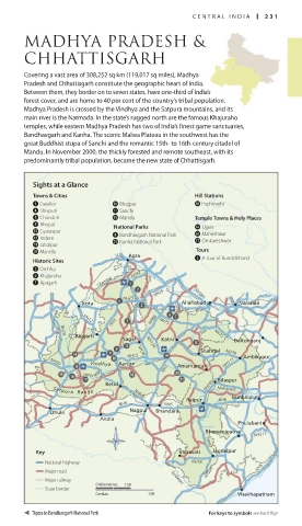
Covering a vast area of 308,252 sq km (119,017 sq miles), Madhya
Pradesh and Chhattisgarh constitute the geographic heart of India.
Between them, they border on to seven states, have one-third of India’s
forest cover, and are home to 40 per cent of the country’s tribal pop ulation.
Madhya Pradesh is crossed by the Vindhya and the Satpura mountains, and its
main river is the Narmada. In the state’s rugged north are the famous Khajuraho
temples, while eastern Madhya Pradesh has two of India’s finest game sanctuaries,
Bandhavgarh and Kanha. The scenic Malwa Plateau in the southwest has the
great Buddhist stupa of Sanchi and the romantic 15th- to 16th-century citadel of
Mandu. In November 2000, the thickly forested and remote southeast, with its
predominantly tribal population, became the new state of Chhattisgarh.
Sights at a Glance
Towns & Cities Hill Stations
1 Gwalior 0 Bhojpur i Pachmarhi
4 Shivpuri q Sanchi
5 Chanderi t Mandu Temple Towns & Holy Places
9 Bhopal National Parks r Ujjain
w Gyaraspur 8 Bandhavgarh National Park y Maheshwar
e Indore a Kanha National Park u Omkareshwar
o Jabalpur
p Mandla Tours
Agra
Historic Sites • 2 A Tour of Bundelkhand
3 Orchha
6 Khajuraho NH92
7 Ajaigarh Chambal
NH25 Ya m una Ganges
NH25
Kota Allahabad • • Varanasi
•
NH3 NH86 NH75
NH12
Son
Rajgarh • NH75
NH79
Sagar Katni • Daltonganj •
• NH12A
Shahdol NH78
NH12 • • Ambikapur
NH26
Vindhya Range Amarkantak NH111
NH59
Narm ada NH7 •
Betul • Bilaspur
• NH200
Satpura Range NH69 Mahanadi
Sambalpur
NH6 • • NH6 Raipur • NH6 •
• Nagpur
Dhule Bhandara
•
Akola
Phulabani •
Bhawanipatna
• NH217
NH43
Key Indravati Jagdalpur
• •
National highway NH16
NH221
Major road NH5
Major railway Godavari
0 kilometres 150
State border •
0 miles 150 Visakhapatnam
Tigers in Bandhavgarh National Park For keys to symbols see back flap
230-231_EW_India.indd 231 26/04/17 11:44 am