
Page 68 - (DK Eyewitness) Travel Guide: Japan
P. 68
66 T OK Y O AREA B Y AREA
Tokyo at a Glance
Japan’s capital is situated on the banks of the Sumida River, by
Tokyo Bay. As the fishing village of Edo it became the shogunate’s
center of power in 1603. The Shitamachi (low city) of merchants
and artisans served the political and intellectual elite in the
Yamanote (high city) on the hills to the west. Renamed Tokyo
and made capital in 1868, the city was devastated by the Great TOKYO
Kanto Earthquake of 1923, followed by World War II bombing.
It has since reinvented itself as one of the world’s most modern,
exciting, and energizing cities. Transportation is efficient: the
easy-to-use Yamanote JR line circles the city, subway lines criss-
cross the center (see Tokyo Subway Map at the end of the book),
and shinkansen lines link it with the rest of the country. It can Locator Map
be difficult to find individual buildings by their addresses (see
p377 and p383). The Tokyo Street Finder (see pp118–27) locates
all the sights, restaurants, and hotels mentioned in this guide.
West Shinjuku (see pp96–7) is an area of NORTHERN
soaring skyscrapers, providing a visible NO.1 TOKYO
manifestation of the corporate wealth of (See pp80–91)
Tokyo. The most impressive buildings are
the Tokyo Metropolitan Government EXPRESSWAY
Offices, designed by Kenzo Tange.
SHINJUKU-D O R I
EXPRESSWAY N O . 4 EXPRES SWAY N O . 9
CENTRAL TOKYO
(See pp68–79)
WESTERN TOKYO
(See pp92–103) DORI
AOYAMA-DORI EXPRESS WAY NO.3 SAKURADA
E X PRESSWA Y N O . 1
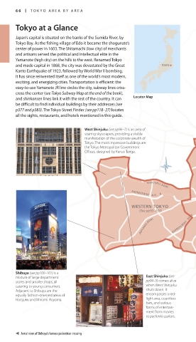
Shibuya (see pp100–101) is a
mixture of large department East Shinjuku (see
stores and smaller shops, all pp94–5) comes alive
catering to young consumers. when West Shinjuku
Adjacent to Shibuya are the shuts down. It
equally fashion-oriented areas of encompasses a red-
Harajuku and Minami-Aoyama. light area, countless
bars, and various
forms of entertain-
ment from movies
to pachinko parlors.
Aerial view of Shibuya’s famous pedestrian crossing
066-067_EW_Japan.indd 66 08/08/16 2:53 pm