
Page 195 - NS-2 Textbook
P. 195
190 NAUTICAL SCIENCES
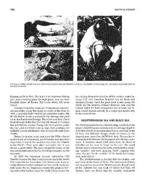
The Exxon Valdez oil spill was one of the worst environmental disasters in history. The tanker is shown top left, grounded atop Bligh Reef in
the Gulf of Alaska.
Russian northern fleet. The latter is an important fishing ice, cutting thousands of miles off the surface routes be-
port and a loading place for high-grade iron ore from hveen U.s. and Canadian Beaufort Sea oil fields and
Swedish mines at Kinma (Kir'-u-na) about 125 miles northern Europe. Since the great circle routes across the
inland. Arctic are the shortest distance behveen Asia and the
Strategic Geography. There are no significant commer- United States for both submarines and aircraft, the re-
cial sea routes across the Arctic ice ocean at this time. In gion would almost certainly be a major operational area
1969, a specially built 150,000-ton icebreaker-tanker, the in the event of ·war.
55 Manhattan, made a successful trip through the pack
ice in the Northwest Passage. The route ,vas from Davis MEDITERRANEAN SEA AND BLACK SEA
Strait through Baffin Bay and Melville Sound to Prudhoe
Bay and Barrow, Alaska. Though the route proved possi- The Mediterranean Sea is a shallow, long, landlocked sea
ble, the costs involved were so high that pipelines are about 1,145,000 square miles in area. Its average depth is
probably a more satisfactory way to move oil south from 4,921 feet, but there are some deep basins west and south
Alaska. of Italy. The Hellenic Trough, south of Greece, is the
Before its demise, every year since the 1950s a Soviet deepest area, more than 16,700 feet deep. The sea lies in
sill'face force of icebreakers, naval vessels, and merchant a broad trench between the European and African conti-
ships tried to transit the northern seas from the Atlantic nents. It stretches about 2,500 miles from the Sh'ait of
to the Pacific. They 'were often successful, but it 'was Gibraltar on the west to Israel on the east. The word
always a great effort. The force resupplied many of the Mediterra1lean comes from the Latin words medius, mean-
tiny settlements started by the Soviet government on the ing "middle," and term, meaning "land"; together they
seacoasts. mean the sea "in the middle" of the lands (of Europe,
In 1958 the American nuclear submarine USS Asia, and Africa).
Nautilus became the first vessel ever to reach the North The Mediterranean is divided into tvvo basins} east
Pole under the ice. Since then, U.S., Soviet, and, nlore re- and west of the Strait of Sicily. The continental shelves
cently, Russian nuclear submarines have made many pa- are very narro"v around the Mediterranean, though most
trols under the ice. Engineers occasionally propose hav- of the Adriatic Sea and Gulf of Gabes (Ga'-bes), off
ing submarine tankers cross the Arctic Ocean under the Tunisia, have sea floors that are actually continental