
Page 210 - NS-2 Textbook
P. 210
OCEANOGRAPHY 205
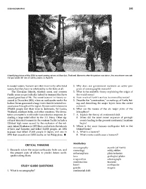
A terrifying picture of the 2004 tsunami coming ashore at Khao lak, Thailand. Moments after this picture was taken, the area shown was sub-
merged under 30 feet of rushing water. D. Rydevik
in coastal waters. Tsunami are often incorrectly called tidal 2. 'Why does OU1' government lnaintain an active pro-
waves, but they have no relationship to the tides at all. gram of oceanographic research?
The Hawallan Islands, Alaskan coast, and western 3. What is the scientific theory explaining the origin of
Pacific areas are periodically lashed by tsunami that have the ,vorld ocean?
caused great loss of life. TIle worst tsunami in history oc- 4. Huw much of Earth's surface is covered by ,vater?
curred in December 2004, when an earthquake under the 5. Describe the "construction," or makeup, of Earth, list-
Indian Ocean generated a huge "wave that devastated sea- ing and describing the major layers from the center
coast areas throughout the region. By some estimates some ouhvard.
370,000 people lost their lives in Indonesia, Sri Lanka, 6. What are the names of the six major plntes of the
Thailand, southern India, and other cOlmhies. The devas- lithosphere?
tation prompted a \vorldwide humanitarian response, in- 7. A. Explain the theory of continental drift.
eluding a large relief effort by the U.S. Navy. Other sig- B. When did the most recent sequence of geologic
nificant historical tSlmami in the '\vestern Pacific include a events leading to the present continental locations
120-foot high wave caused by the explosion of the vol- begin?
canic island Krakatoa in 1883 that crashed into the islands 8. Where is the most famous earthquake belt in the
of Java and Sumatra and killed 36,000 people, an 1896 United States?
tsunami that killed 27,000 people in Japan, and one in 9. A. VVhat is a tSllnami?
1976 that caused over 5,000 deaths in the Philippines. III B. vVhat events could cause a tsunami?
Vocabulary
CRITICAL THINKING
oceanography mantle (of Earth)
1. Research where the major earthquake belts are, and cosmology eddy, eddies
the present state of efforts to predict future earth- asthenosphere plate tectonics
quakes along them. 1ava geological plates
evaporation seismograph
condensation tSlmami
basalt earthquake
STUDY GUIDE QUESTIONS
granite magnla
1. What is oceanography? continental drift