Page 157 - DK Children's Encyclopedia
P. 157

Maps                                                                              SEE ALSO

                                                                                               ▸ ▸ Compass  p.70
                                                                                               ▸ ▸ Explorers  p.96
           A map is a detailed picture of what the ground looks like                           ▸ ▸ Measuring  p.159
           from above, as if you were flying over it. Maps tell us how                         ▸ ▸ Exploration
           big an area is and what can be found there. Maps can be of                           pp.180–181

           anything, from the whole world to the insides of buildings.                         ▸ ▸ Navigation  p.182
                                                                                               ▸ ▸ Transportation
                                                                                                pp.258–259
                                       1
                                                      2
                                                                     3
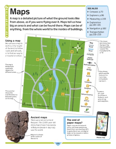
       Using a map                                                                  4                     This shows
       We can use a map to   A                                                     N            Key       which direction
       work out the height                                                                     Road       the top of the
                                                                                                          map is pointing
       of the land, to follow                                                W         E                  toward. This
       roads and railroads,                                                                    River      is usually north,
       or to find our way to                                                      S                       or “N.”
       a hospital or school.                                                                 Footpath
                           B
                                                                                             Railroad


       The map is                                                                         Railroad station
       divided into
       a grid with
       squares for       C                                                                  Bridge
       different areas.                                                                                  A key shows
                                                                                                         which real-life
                                                                                            Castle       features the
                                                                                                         map’s lines
                                                                                                         and symbols
                                                                                                         represent.
                                                                                          Campsite

                        D
                                                                                          Hospital
       The scale bar                                                                                    Symbols
       shows the                                                                                        are used
       real-life distance                                                              Nature reserve   for different
       between points                                                                                   features, such
       on the map.
                       E                                                                                as buildings
                                                                                          School        and campsites.
                         0 km / O miles
                                        1 km / 0.62 miles
                                                                                      Sports center

                                                                                          Forest

                                 Ancient maps
                                 Maps were less accurate in             The end of
                                 the past. This 2,500-year-old          paper maps?
                                 stone map shows how people             Paper maps are still around
                                 in Babylon (modern-day Iraq)           today, but fewer people use
                                 saw the world.                         them. Most cars now have GPS
                                                                        to guide the driver, and digital
                                                                        maps can be viewed on mobile
                                 Babylon is shown                       phones or laptops.
                                 at the center of                                                      Phone map
                                 the world.

                                                             155


   US_155_Maps.indd   155                                                                                        05/06/2017   14:27
   152   153   154   155   156   157   158   159   160   161   162