
Page 30 - GeoPRISMS_Newsletter_Spring2018_Neat
P. 30
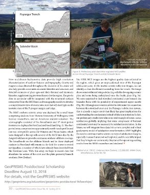
CMP Number
               7000     7200      7400      7600      7800
            4
                 Puysegur Trench
            5

            6

            7 8                                       A
           Two-way Travel-time (s)  2 8800 625 m  9000  9200  9400  9600


            3    Solander Basin

            4
                                                                                                         Onshore seismograph
                                                                                                   deployment with the Takitimu
            5                                                                                       Mountains in the background

            6                                          B    Figure 3. Preliminary post-stack time migrated MCS profiles
               625 m                                        across the (a) Puysegur Trench and (b) Solander Basin

        New multibeam bathymetry data provide high-resolution  The SISIE MCS images are the highest quality data collected in
        characterization of seafloor features and topography. Gravity and  the region, which gives an unprecedented view of the Puysegur
        magnetic data obtained throughout the duration of the cruise will  subduction zone. In the marine seismic reflection images, we can
        also help provide constraints on crustal densities and structure, and  identify a clear décollement extending from the trench. The image
        detailed estimates of plate ages and their thermal and kinematic  shows some sediment being subducting with the downgoing oceanic
        histories, supplementing previous datasets for the region. The gravity  plate and some being underplated onto the Pacific plate (Fig. 3a).
        data in particular will be integrated with the structural surfaces  We were surprised to find stretched continental crust beneath the
        interpreted from the MCS lines and tomography models to develop  Solander Basin with the possibility of serpentinized upper mantle
        a comprehensive view of crustal structure that will shed light on the  (Fig. 3b). Although more work is needed to determine the connection
        isostatic state of the Puysegur margin and ridge.      between this stretched crust and the Puysegur subduction system,
        The SISIE onshore seismic array was deployed by a small team   this is already a major result that likely has great implications for
        comprising students from Victoria University of Wellington, GNS   understanding the mechanisms behind subduction initiation. In fact,
        Science researchers, and an American student volunteer. The   our preliminary results leave almost no real example of ocean-ocean
        seismographs consisted of five broadbands and 37 short-period   subduction globally, implying that some component of buoyant
        instruments deployed in Fiordland and Southland (Fig. 1). The short   continental crust may be necessary for subduction initiation. In the
        period array comprises two approximately north-south profiles and   future, we will integrate these data into a more complex and robust
        one east-west profile across the Winston and Waiau basins, which   geodynamic model of subduction zone formation. SISIE highlights
        were designed to line up with several of the MCS lines shot by the   the need to continue marine seismic surveys of subduction margins,
        Langseth offshore to provide continuous onshore-offshore coverage.   especially in areas that are not well explored, and the scientific impact
        The broadbands on the offshore Islands and in those deployed   that they bring to our community. Stay tuned for upcoming exciting
                                                               results from the SISIE researchers and students! ■
        onshore in Fiordland will remain in the field for a year to record
        earthquakes, a number of which have already been recorded from
        the Fiordland area. With this array, we hope to record data that   Mitchell et al, (2012), Undersea New Zealand, 1:5,000,000. NIWA Chart,
        elucidates the nature of the crust and the plate geometry beneath   Miscellaneous Series No. 92.
        southern New Zealand.


     GeoPRISMS Postdoctoral Scholarship

     Deadline August 13, 2018
     For details, visit the GeoPRISMS website:

     http://geoprisms.org/education/geoprisms-postdoctoral-fellowships/


        30  •  GeoPRISMS Newsletter  Issue No. 40  Spring 2018