
Page 29 - GeoPRISMS_Newsletter_Spring2018_Neat
P. 29
A total of 28 UTIG ocean-bottom seismometers (OBSs) were
deployed on two key transects which span from the subducting
Australian plate, across the Puysegur trench and ridge, over the
Solander Basin, and onto the Campbell Plateau (Fig. 1). Students
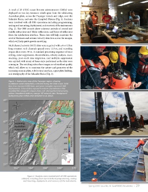
were involved with all OBS operations including programming,
sealing and mounting, deployment, and recovery of the instruments
(Fig. 2). The OBS records show coherent arrivals of crustal and
mantle refractions and Moho reflections, and hints of reflections
from the subduction interface. These data will help constrain the
crustal thickness and seismic velocity structure across the margin,
which will help guide gravity modeling.
Multichannel seismic (MCS) data were acquired with a 4 or 12 km
long streamer, with channels spaced every 12.5 m, and recording
airgun shots every 50 m. A standard processing sequence of trace
editing, noise suppression, deconvolution, velocity analysis, mute,
stacking, post-stack time migration, and multiple suppression
was applied, with many of these steps performed as the data were
coming in. The resulting subsurface images are of excellent quality,
which will allow us to constrain the nature and geometry of the
incoming oceanic plate, subduction interface, upper plate faulting,
and stratigraphy of the Solander Basin (Fig. 3).
Figure 1. Bathymetry map of the Puysegur region, showing
multibeam swath bathymetry collected during the SISIE cruise. Solid
blue lines represent MCS lines, and green triangles represent OBS
deployments. Colored dots represent onshore seismometers that
recorded the Langseth’s airgun shots; red: short-period instruments,
yellow: broadband stations, orange: NZ network sites. Background
bathymetry from NIWA chart (Mitchell et al. 2012).
Figure 2. Students were involved with all OBS operations
onboard, including (from top to bottom) programming, sealing
and mounting, deployment, and recovery of the instruments.
Spring 2018 Issue No. 40 GeoPRISMS Newsletter • 29