
Page 291 - (DK Eyewitness) Travel Guide - Morocco
P. 291
SOUTHERN MOROC C O & WESTERN SAHAR A 289
Key
0 km 40
Motorway
0 miles 40
Major road
Minor road
Track
International border
Essaouira Disputed territory border
Marrakech
Summit
TAROUDANNT Ouarzazate Pass
AGADIR Wadi Sous
Tioute
Biougra
Inchadèn
SOUSS MASSA Igherm
NATIONAL PARK Aït-Baha a s
Pass
Had-Belfa Tioulit t l Tizi-Touzlimt
Sidi Moussa A IGHERM TO TATA
Aglou Jbel Lekst
2359m Souk-Khemis- Tata
TIZNIT Assaka TAFRAOUTE d’Issafen
Mirleft t i Foum Zguid
n Jbel Tililt
1739m
A Ida Oussemlal Bou-Zarif
SIDI IFNI Souk-Tlata- AKKA
des-Akhasass
A TLANTIC Bou-Izakarn Oua-Belli Wadi Draa
OCEAN Aït-Herbil
GUELMIM Foum-el-Hassan
Plage
Blanche El Abiar Aït Bekkou
Targoumait
D j e b e l O u a r k z i z
Tan Tan Plage Assa
TAN TAN
Djebel Taskalouine AouÏnet-Torkoz
Wadi Draa
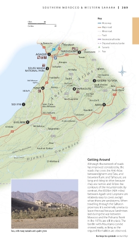
Dar-Chebika Getting Around
El-Mahbas
Reserve Although the network of roads
Naturelle Sidi has improved considerably, the
TARFAYA Naila Akhfennir M'sied roads that cross the Anti-Atlas
Abetteh
between Igherm and Tata, and
between Tiznit and Tafraoute, are
long and tiring to drive because
they are narrow and follow the
As-Sakn contours of the mountainside. By
contrast, the 650 km (404 miles)
El Hagounia
Daoura between Agadir and Laayoune are
relatively easy to cover, except
when there are sandstorms. When
travelling through the Saharan
Al Gada
LAAYOUNE provinces it is extremely unwise to
Smara leave the road because landmines
Dakhla laid during the war between
Morocco and the Polisario Front
in the 1970s are still in place. The
border with Mauritania can be
crossed easily, as long as the
Tata, with many kasbahs and a palm grove required formalities are observed.
For keys to symbols see back flap
288-289_EW_Morocco.indd 289 09/08/16 11:20 am