
Page 254 - (DK Eyewitness) Travel Guide - Ireland
P. 254
252 IRELAND REGION B Y REGION
Trim Castle set in water meadows beside the River Boyne
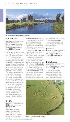
r Hill of Tara The Trim Visitor Centre houses trail leads to the Saints Peter and
a multimedia exhi bi tion on the Paul Cathedral further east.
Road map D3. Nr Killmessan Village,
Co Meath. Tel 046 902 5903. town’s history. It is also the A lovely walk leads from the
@ to Navan. Open mid-May–mid- starting point for a heritage castle along the River Boyne to
Sep:10am–6pm daily (last adm 1hr trail, which takes in eight sites, Newtown Abbey.
before closing). & Interpretative including the town’s two castles
Centre. 8 ∑ hilloftara.org and two cathedrals. + Trim Castle
The dramatic Trim Castle was Tel 046 943 8619. Open mid-Mar–Oct:
A site of mythical importance, Tara founded in the 12th century 10am–6pm daily; Nov–mid-Mar:
was the political and spirit ual by Hugh de Lacy, a Norman 9am–5pm Sat & Sun. & 8
centre of Celtic Ireland and the knight, and is one of the largest obligatory. ∑ heritageireland.ie
seat of the High Kings until medieval castles in Europe. It
the 11th century. The spread of makes a spectac ular backdrop
Christianity, which eroded the for films and was used in Mel
importance of Tara, is marked by a Gibson’s film Braveheart in 1995. y Mullingar
statue of St Patrick. The symbolism Over the river is Talbot Castle, Road map C3. Co Westmeath.
of the site was not lost on Daniel an Augustinian abbey converted * 25,000. £ @ n Market Square
O’Connell (see p46), who chose to a manor house in the 15th (044 934 8650). ∑ mullingar.ie
Tara for a rally in 1843, attended century. Just north of the abbey
by over one million people. is St Patrick’s Cathedral, which The county town of West-
Tours from the Interpretative incorporates part of a medieval meath is a prosperous but
Centre take in a Stone Age church with a 15th-century unremarkable market town
passage grave and Iron Age hill tower and sections of the encircled by the Royal Canal,
forts, which, to the untutored original chancel. From here the which with its 46 locks links
eye, look like mere hollows and
grassy mounds. Clearest is the
Royal Enclosure, an oval fort, in
the centre of which is Cormac’s
House containing the “stone of
destiny” (Liath Fáil), fertility
symbol and inaugur ation
stone of the High Kings. Most
moving, however, is the
poignant atmosphere and
views over the Boyne Valley.
t Trim
Road map D3. Co Meath. * 6,500.
@ n Castle St (046 943 7227).
( Fri. ∑ meath.ie
Trim is one of the most
pleasing Midlands market
towns. A Norman stronghold
on the River Boyne, it marked a
boundary of the Pale (see p136). Aerial view of Iron Age forts on the Hill of Tara
For hotels and restaurants in this region see p302 and pp321–3
252-253_EW_Ireland.indd 252 08/03/17 11:07 am
Eyewitness Travel LAYERS PRINTED:
Catalogue template “UK” LAYER
(Source v2.1)
Date 5th December 2012
Size 125mm x 217mm