
Page 136 - (DK Eyewitness) Travel Guide - Brittany
P. 136
134 BRIT T AN Y REGION B Y REGION
w St-Renan
Road map: A1. 9 km (6 miles) north-
west of Brest via the D5. * 7,900. @
from Brest or Landerneau. n Place
du Vieux Marché; (02) 98 84 23 78.
( Sat. ∑ tourisme-saint-renan.fr
Until the early 17th century,
St-Renan (Lokournan in Breton)
was an important town with a
court of justice that served 37
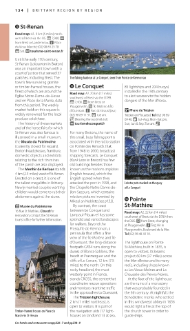
parishes, including Brest. The The fishing harbour at Le Conquet, seen from Pointe de Kermorvan
town’s few surviving granite
or timber-framed houses, the e Le Conquet 85 lightships and 204 buoys)
finest of which are around the Road map: A2. 20 km (12 miles) installed in the 19th century
Église Notre-Dame-de-Liesse southwest of Brest via the D789. to alert seamen to the hidden
and on Place de la Mairie, date * 2,400. @ from Brest or dangers of the Mer d’Iroise.
from this period. The weekly Plougonvelin. g Île Molène & Île
market held on this square is d’Ouessant. n Parc de Beauséjour; Phare de Trézien
widely renowned for the local (02) 98 89 11 31. ( Tue am. Trézien en Plouarzel. Tel (02) 98 89
produce sold there. _ Blessing the sea (mid-Jul). 69 46. 8 Jul–Aug: Mon–Sat pm,
The history of these markets ∑ tourismeleconquet.fr Sun; Jun & Sep: Tue am. &
and of the horse fairs for which
St-Renan was also famous is For many Bretons, the name of
illustrated in a small museum, this small, busy fishing port is
the Musée du Patrimoine associated with the radio station
(currently closed for repairs). on Pointe des Renards that,
Breton head dresses, furniture, from 1948 to 2000, broadcast
domestic objects and exhibits shipping forecasts. Le Conquet
relating to the rich tin mines (Konk Leon in Breton) has few
of the parish are also displayed. old buildings besides those
The Menhir de Kerloas stands known as the maisons anglaises
4 km (2.5 miles) west of St-Renan. (English houses), which the
Erected on a crest, it is one of English spared when they
the tallest megaliths in Brittany. attacked the port in 1558, and Lobster pots stacked on the quay
Newly married couples wanting the Chapelle Notre-Dame-de- at Le Conquet
children would come to rub their Bon-Secours, which contains
abdomens against the stone. mission pictures invented by r Pointe
Mikeal an Nobletz (see p133).
E Musée du Patrimoine By contrast, the coast St-Mathieu
16 Rue St-Mathieu. Closed for between Le Conquet and Road map: A2. 22 km (14 miles)
renovation; contact the St-Renan Lampaul-Plouarzel has some southwest of Brest via the D789 then
tourist office for further information. splendid and varied landscapes the D85. £ from Brest, changing
for walkers. Beyond the at Plougonvelin. n Trez Hir in
Presqu’île de Kermorvan, a Plougonvelin, Boulevard de la Mer.
peninsula that offers a fine Tel (02) 98 48 30 18.
view of the Île Molène and Île
d’Ouessant, the long-distance The lighthouse on Pointe
footpath GR34 runs along the St-Mathieu, built in 1835, is
dunes of Blancs-Sablons, the open to visitors. Its beams
beach at Porsmoguer and the project 60 km (37 miles) across
cliffs of Le Corsen, 12 km (7.5 the Mer d’Iroise and its many
miles) to the north. On this reefs, including those known
rocky headland, the most as Les Vieux-Moines and La
westerly point in France, Chaussée des Pierres-Noires.
stands CROSS, the centre that At the foot of the lighthouse
coordinates rescue operations are the ruins of a monastery
and monitors maritime traffic that was probably founded in
in the approaches to Ouessant. the 6th century. At nightfall, the
The Trézien lighthouse, Benedictine monks who settled
2 km (1 mile) northeast, is in this windswept abbey in 1656
open to visitors. It is part of would light a fire at the top of
Timber-framed houses on Place du the navigation aids (17 light- the church tower in order to
Marché in St-Renan houses on land and 13 at sea, guide ships.
For hotels and restaurants seepp226–7 and pp238–9
134-135_EW_Brittany.indd 134 11/3/16 1:02 PM