
Page 137 - (DK Eyewitness) Travel Guide - Brittany
P. 137
NOR THERN FINISTÈRE 135
t Ouessant
Archipelago
Road map: A1. * 1,207.
g Motorboats run by Penn Ar Bed
(02 98 80 80 80). Flights from Finist’Air,
(02) 98 84 64 87. n Place de L’Eglise,
Ouessant (02) 98 48 85 83.
∑ ot-ouessant.fr
Battered by strong westerly
winds and lashed by the sea,
the seven islands and dozen
islets that make up the Ouessant
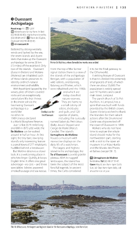
archipelago lie some 20 km Pointe St-Mathieu, where Benedictine monks once settled
(13 miles) off the mainland. Only
two of the islands – Ouessant From the top of the former it to be the final gateway to
(Eussa in Breton) and Molène signal station there is a view of the Otherworld.
(Molenez) are inhabited. Each the islands of the archipelago: A striking feature of Ouessant
of these islands preserves its Beniget, with a population of is that it is divided into extremely
identity and rich natural wild rabbits, and Banneg, small parcels of land, of which
environment and wildlife. Balaneg and Trielen, which there are about 55,000. The
With heathland lapped by the were inhabited until the 1950s population is widely spread
waves, piles of lichen-covered and which are over 92 hamlets and a small
rocks and an exceptionally today classified main town, Lampaul.
varied plant life that thrives nature reserves. The parish church of St-Pol-
in the moist salt air, the They are home to Aurélien, in Lampaul, has a
fascinating Ouessant a small colony of spire that was built with funds
archipelago is a otters, shelducks provided by the British crown.
world like Shelduck on the and gulls, and 120 Queen Victoria wished to thank
no other. In Ile d’Ouessant species of plants, the islanders for their valiant
1989 Unesco declared including the curiously actions after the Drummond
it a World Biosphere Reserve. named Sabot du Petit Jésus Castle was shipwrecked off
Just 1.2 km (0.75 mile) long (Baby Jesus’s Slipper) and the coast of Ouessant in 1896.
and 800 m (875 yds) wide, the Cierge de Marie (Mary’s Walkers who do not have
Île Molène can be walked Candle). The island’s time to explore the whole
around in half an hour. At first Semaphore de Molène island should make for the
sight, the tiny bare, low-lying houses a museum with northwestern part, starting
island’s only interesting feature interactive displays on the with a visit to the open-air
is a small town of 277 inhabitants daily life of a watchman. museum in Le Niou Huella
huddled behind a breakwater. The largest and highest and the Musée des Phares
But Molène deserves a closer island in the archipelago, the et Balises (see pp136–7).
look: it is a welcoming place in Île d’Ouessant is a wild granite
which to linger. Quirkily, it keeps plateau. With its rugged E Sémaphore de Molène
English time. It offers one great landscapes, the island has Île Molène. Tel (02) 98 07 39 47.
advantage – no cars – and three been the subject of the most Open May & Jun: 9am–6pm Sat &
specialities: lobster, seaweed- fanciful legends. In ancient Sun; Jul–Sep: 9am–6pm daily; call
smoked sausage and sea rescue. times, the Celts considered ahead for rest of year.
The Ile d’Ouessant, the largest and highest island in the Ouessant archipelago, seen from Corz
134-135_EW_Brittany.indd 135 11/3/16 1:02 PM