
Page 161 - (DK Eyewitness) Travel Guide - Brittany
P. 161
SOUTHERN FINISTÈRE 159
rises to height of more than
70 m (230 ft). Pointe du Raz (Beg
ar Raz in Breton) is extended by
a spine of sub merged rocks,
on the most distant of which
stands a lighthouse, the Phare
de la Vieille.
In fine weather, the Île de
Sein and the Ar Men lighthouse
are visible from here. On the
north side, the sea has carved
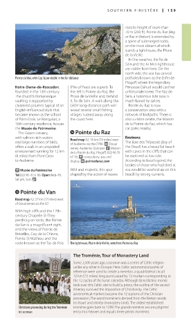
Pointe du Van, with Cap Sizun visible in the far distance potholes known as the Enfer de
Plogoff, where the legendary
Notre-Dame-de-Roscudon, (Pile of Peas) are superb. To Princesse Dahud would cast her
founded in the 13th century. the left is Pointe du Raz, the un fortunate lovers. The Raz de
The church’s Roman esque Phare de la Vieille and, behind Sein, a notorious tide race, is
vaulting is supported by it, Île de Sein. A walk along the much feared by sailors.
clustered columns typical of an GR34 long-distance path will Pointe du Raz is now
English-influenced style that reveal several small fishing a conservation area with a
became known as the school villages tucked away along network of footpaths. There is
of Pont-Croix. Le Marquisat, a the coast here. also a visitor centre, the Maison
16th-century residence, houses de la Pointe du Raz, which has
the Musée du Patrimoine. car parks nearby.
The Goyen estuary, r Pointe du Raz
with salmon-rich waters Road map A2. 16 km (10 miles) west Environs
and large numbers of birds, of Audierne via the D784. @ Douar- The Baie des Trépassés (Bay of
offers a walk in an unspoiled nenez, Audierne, Quimper. n Maison the Dead) has a beautiful beach
environment running for 12 km de la Pointe du Raz, Plogoff; (02) 98 70 with caves in the cliffs that can
(8 miles) from Pont-Croix 67 18. h compulsory; pay and be explored at low tide.
to Audierne. display. ∑ pointeduraz.com According to local legend, the
bodies of those who had died at
E Musée du Patrimoine Wild and majestic, this spur sea would be washed up on this
Tel (02) 98 70 51 86. Open Wed–Fri, shaped by the action of waves beach by strong currents.
Sat pm, Sun. &
e Pointe du Van
Road map A2. 27 km (17 miles) west
of Douarnenez via the D7.
With high cliffs and the 17th-
century Chapelle St-They
perching on rocks, the Pointe
du Van is a magnificent sight,
and the views of Pointe de
Brézellec, Cap de la Chèvre,
Pointe St-Mathieu and the
rocks known as the Tas de Pois The lighthouse, Phare de la Vieille, seen from Pointe du Raz
The Troménie, Tour of Monastery Land
Some 2,500 years ago, Locronan was a centre of Celtic reli gion
unlike any other in Europe. Here, Celtic astronomical points of
reference were used to create a nemeton, a quadrilateral circuit
12 km (7.5 miles) long punctuated by 12 markers corresponding to
the 12 cycles of the lunar calendar. Although Benedictine monks
took over this Celtic site to build a priory, the outline of the sacred
itinerary survived the imposition of Christianity. The Celtic
astronomical markers became the 12 stations of the Christian
procession. The word troménie is derived from the Breton words
tro (tour) and minihy (monastery land). The oldest-established
Christians processing during the Troménie troménie goes back to 1299. The grande troménie secures pilgrims’
in Locronan entry into heaven and equals three petites troménies.
158-159_EW_Brittany.indd 159 11/3/16 1:03 PM