
Page 192 - (DK Eyewitness) Travel Guide - Brittany
P. 192
190 BRIT T AN Y REGION B Y REGION
Exploring the Golfe du Morbihan
Focal point of the Morbihan region, the Golfe du Morbihan
is 20 km (12 miles) wide and covers 12,000 ha (30,000 acres).
The gulf, with its deeply indented coastline and many islands, can
be explored by boat from Vannes, Port-Navalo, Auray, La Trinité or
Locmariaquer. Tourism, together with shellfish and oyster farming,
are major industries here, and, although fishing, sailing and other
activities have also developed, the gulf is a haven for bird life. Detail of the stoup in the Église
The land around it is dotted with menhirs, dolmens and tumuli. St-Gildas-de-Rhuys
} Pointe d’Arradon The Île d’Arz (Bear Island), Cairn de Gavrinis
Road map D3. 9 km (6 miles) south which attracts fewer visitors Road map D4. Île Gavrinis. Tel (02)
west of Vannes via the D101 then than the Île aux Moines, can 97 57 19 38 g LarmorBaden.
the D101a. n (Jun–Sep) 2 Bouruet be explored on foot as it is Open Apr–Sep: daily (make
Aubertot, Arradon; (02) 97 44 77 44. only 3 km (2 miles) long and reservations 24 hrs in advance). & 8
( Tue & Fri. 1 km (0.5 mile) wide. The low, Discovered in 1832, this
The Pointe d’Arradon is whitewashed, slateroofed singlechambered passage
sometimes referred to as the houses and lush vegetation grave is considered to be
“Riviera of the Gulf”. There are here create a typical image unusual both on account of its
some stunning houses here and of Brittany. construction – of a type that
the view takes in the Îles Logoden, The island is dotted with makes it one of the oldest in the
Île Holavre and Île aux Moines. menhirs and dolmens, with a region – and because of its
particular concentration on engravings. When the writer
} Île d’Arz Pointe de Liouse. The Église Prosper Mérimée visited it in
Road map D4. g 15 mins from NotreDame, in the town, has 1835, he was struck by “stones
Vannes (02) 97 44 44 40; Navix, (02) 97 Romanesque capitals decorated covered in peculiar drawings…
46 60 00. n Mairie, Île d’Arz; (02) 97 with grotesque figures. Boating curved, straight, broken and
44 31 14. _ Pardon, on Île d’Hur (late enthusiasts will find two sailing wavy lines combined in a
Jul); regattas (Aug). schools on the island. hundred different ways”.
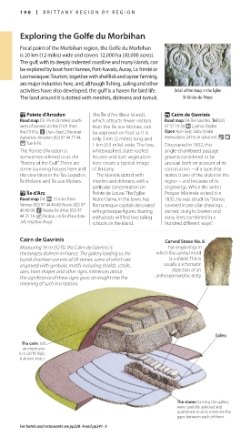
Cairn de Gavrinis Carved Stone No. 8
Measuring 16 m (52 ft), the Cairn de Gavrinis is has engravings in
the longest dolmen in France. The gallery leading to the which the central motif
burial chamber consists of 29 stones, some of which are is a shield. This is
engraved with symbolic motifs including shields, scrolls, usually a schematic
axes, horn shapes and other signs. Inferences about depiction of an
the significance of these signs gives an insight into the anthropomorphic deity.
meaning of such inscriptions.
Gallery
The cairn, still
an impressive
6 m (20 ft) high,
is almost intact.
The stones forming the gallery
were carefully selected and
positioned so as to minimize the
gaps between each of them.
For hotels and restaurants see pp228–9 and pp241–3
190-191_EW_Brittany.indd 190 11/3/16 1:03 PM