
Page 28 - (DK Eyewitness) Travel Guide - The Netherlands
P. 28
26 INTRODUCING THE NE THERLANDS
Holding Back the Water
Recent floods in the Netherlands’ river valleys,
particularly the one which occurred in
1995, when 200,000 people needed to be
evacuated from the area, have shown what
a threat water continues to pose to the
Netherlands. The only way the sea can be held
back is by dams, but in order to contain rivers
at high tide, the country is adopting a new
approach, that of “controlled flooding”. Flooded farm in Gelderland (1995)
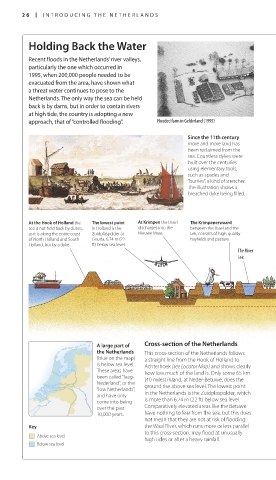
Since the 11th century
more and more land has
been reclaimed from the
sea. Countless dykes were
built over the centuries
using elementary tools,
such as spades and
“burries”, a kind of stretcher.
The illustration shows a
breached dyke being filled.
At the Hook of Holland the The lowest point At Krimpen the IJssel The Krimpenerwaard
sea is not held back by dunes, in Holland is the discharges into the between the IJssel and the
as it is along the entire coast Zuidplaspolder at Nieuwe Maas. Lek, consists of high-quality
of North Holland and South Gouda, 6.74 m (22 hayfields and pasture.
Holland, but by a dyke. ft) below sea level.
The River
Lek
A large part of Cross-section of the Netherlands
the Netherlands This cross-section of the Netherlands follows
(blue on the map) a straight line from the Hook of Holland to
is below sea level. Achterhoek (see Locator Map) and shows clearly
These areas have how low much of the land is. Only some 65 km
been called “laag- (40 miles) inland, at Neder-Betuwe, does the
Nederland”, or the ground rise above sea level. The lowest point
“low Netherlands”,
and have only in the Netherlands is the Zuidplaspolder, which
come into being is more than 6.74 m (22 ft) below sea level.
over the past Comparatively elevated areas like the Betuwe
10,000 years. have nothing to fear from the sea, but this does
not mean that they are not at risk of flooding:
Key the Waal River, which runs more or less parallel
to this cross-section, may flood at unusually
Above sea level
high tides or after a heavy rainfall.
Below sea level
026-027_EW_Netherlands.indd 26 16/01/17 12:02 pm
Eyewitness Travel LAYERS PRINTED:
Feature template “UK” LAYER
(SourceReport v1.3)
Date 18th October 2012
Size 125mm x 217mm