
Page 26 - (DK Eyewitness) Travel Guide - Southwest USA & National Parks
P. 26
24 INTRODUCING THE SOUTHWEST A POR TR AIT OF THE SOUTHWEST 25
Landscapes of the Southwest
The colorful, beautiful, and varied landscape of the
Southwest has been shaped by volcanic eruption, uplift,
and wind and water erosion. For much of the Paleozoic Era
(between about 570 to 225 million years ago) the region was
mostly covered by a vast inland sea that deposited over
10,000 ft (3,048 m) of sediment, which eventually hardened
into rock. Following the formation of the Rocky Mountains,
some 80 million years ago, rivers and rainfall eroded the rock Coral Pink Sand Dunes State Large areas of grassland once covered the broad
layers and formed the deep canyons and arches that Park’s shimmering pink sand river basins of New Mexico and Arizona. However,
distinguish the landscape of the Southwest. dunes cover more than little of this landscape remains, as it was largely
50 percent of this 5.8-sq-mile
turned to desert through overgrazing by Anglo-
The central geological feature of the region (15-sq-km) park (see p153). American ranchers in the 1880s.
is the Colorado Plateau, which covers some
130,000 sq miles (336,700 sq km). The
plateau is cut through by many canyons,
including Grand Canyon (see pp62–7).
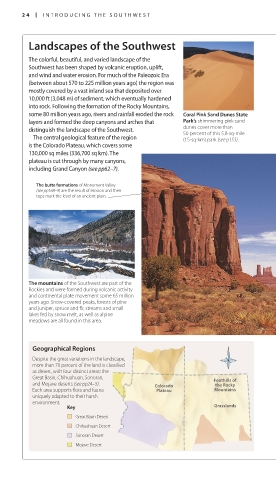
The butte formations of Monument Valley
(see pp168–9) are the result of erosion and their
tops mark the level of an ancient plain. Canyons such as this one at Zion National
Park (see pp158–9) started life when a stream
began to cut a relentless path into the rock.
As the cut grew deeper, erosion by wind, rain,
and ice began widening it, and the stream
carried away the debris.
The orange sand of Monument
Valley’s desert floor is dotted
with sagebrush.
The mountains of the Southwest are part of the Mesas, Buttes, and Spires
Rockies and were formed during volcanic activity
and continental plate movement some 65 million Like canyons, mesas come in many sizes.
years ago. Snow-covered peaks, forests of pine Some very large ones measure over 100 miles
and juniper, spruce and fir, streams and small (161 km) across and are often the result of
lakes fed by snow melt, as well as alpine land being forced up by geological forces.
meadows are all found in this area. Other mesas, buttes, and spires are hard-rock
remains left behind as a large plain cracked,
and then eroded away.
Geographical Regions
Despite the great variations in the landscape,
more than 70 percent of the land is classified
as desert, with four distinct areas: the
Great Basin, Chihuahuan, Sonoran, Foothills of
and Mojave deserts (see pp24–5). Colorado the Rocky
Each area supports flora and fauna Plateau Mountains
uniquely adapted to their harsh The Colorado Plateau is crossed
environment.
Key Grasslands by river-forged canyons. Elevations
here range from 2,000 ft (600 m)
Great Basin Desert above sea level to around
Chihuahuan Desert 13,000 ft (3,900 m). Dramatic
variations in the landscape include
Sonoran Desert desert, verdant river valleys,
Mojave Desert thickly forested peaks, and eroded
bizarre sandstone formations.
024-025_EW_SW_USA.indd 24 28/11/17 12:38 PM 024-025_EW_SW_USA.indd 25 28/11/17 12:39 PM
Eyewitness Travel LAYERS PRINTED:
Feature template “UK” LAYER
(SourceReport v1.3)
Date 18th October 2012
Size 125mm x 217mm