
Page 426 - (DK) Ocean - The Definitive Visual Guide
P. 426
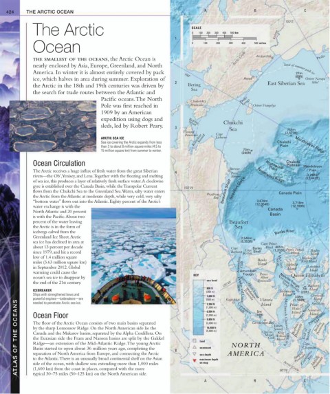
424 THE ARCTIC OCEAN A B C
150˚E
The Arctic SCALE 200 300 400 500 km
0
100
1 Kolyma
Ocean 0 100 200 300 400 500 miles
THE SMALLEST OF THE OCEANS, the Arctic Ocean is Arctic Circle Ambarchik Proliv
nearly enclosed by Asia, Europe, Greenland, and North
America. In winter it is almost entirely covered by pack limit of summer pack ice
27m
(89ft)
180˚
ice, which halves in area during summer. Exploration of Pevek Ostrov Novaya
2 East Siberian Sea Sibir’
the Arctic in the 18th and 19th centuries was driven by Bering
Sea
the search for trade routes between the Atlantic and
Pacific oceans. The North Proliv
Chukotskiy Longa
Pole was first reached in Peninsula Ostrov Vrangelya
1909 by an American
expedition using dogs and
Chukchi
Bering
Strait
sleds, led by Robert Peary. 3
755m
Seward Sea (2,477ft)
Peninsula Cape
ARCTIC SEA ICE Kotzebue Sound Lisburne
Sea ice covering the Arctic expands from less Chukchi
than 3 to about 6 million square miles (4.5 to Plain Mendeleyev Ridge
15 million square km) from summer to winter. 73m
(240ft)
Ocean Circulation Northwind Chukchi Mendeleyev
Plateau
Barrow Plain
The Arctic receives a huge influx of fresh water from the great Siberian 4 Point Plain
3,792m
rivers—the Ob’, Yenisey, and Lena. Together with the freezing and melting Barrow Northwind Ridge (12,442ft)
of sea ice, this produces a layer of relatively fresh surface water. A clockwise
gyre is established over the Canada Basin, while the Transpolar Current
150˚W Beaufort Slope
flows from the Chukchi Sea to the Greenland Sea. Warm, salty water enters Beaufort Shelf Canada Plain
Prudhoe
the Arctic from the Atlantic at moderate depth, while very cold, very salty Bay
3,674m
“bottom water” flows out into the Atlantic. Eighty percent of the Arctic’s (12,054ft) 3,718m
water exchange is with the (12,199ft)
North Atlantic and 20 percent Canada
is with the Pacific. About two Basin
percent of the water leaving Beaufort
the Arctic is in the form of Sea
icebergs calved from the Banks Rise
Greenland Ice Sheet. Arctic 2,546m
sea ice has declined in area at Mackenzie (8,353ft) Cape Prince
about 13 percent per decade Cape Banks Alfred 401m
Cape
since 1979, and hit a record Bathurst Kellett Shelf (1,316ft) Prince Patrick Borden
Island
Island
low of 1.4 million square Mackenzie
miles (3.63 million square km) Amundsen Gulf Banks Strait McClure Melville King Island
Island
in September 2012. Global Island Lougheed
Island
warming could cause the Amundsen
KEY Trough Prince Queen Elizabeth
ocean’s sea ice to disappear by Albert
sea level Peninsula Melville Trough
the end of the 21st century. 120˚W Viscount Melville Bathurst
Strait
800 ft Strait Prince Albert Sound 7m Island
ICEBREAKER (250 m) Dolphin and Union Stefansson (23ft)
Ships with strengthened bows and 1,600 ft Peninsula Island 338m Cornwallis
Island
powerful engines—icebreakers—are (500 m) Kugluktuk Gulf (16ft) Island McClintock Channel Prince of Peel Sound Resolute
Wollaston
Victoria
(1,168ft)
ATLAS OF THE OCEANS The floor of the Arctic Ocean consists of two main basins separated 8 land (3,000 m) AMERICA Queen Sound Rae Strait Boothia Simpson Chapman Inlet Peninsula
needed to penetrate Arctic sea ice.
3,300 ft
(1,000 m)
Wales
Somerset
5m
6,500 ft
Island
Prince Regent
Island
Coronation
Ocean Floor
(2,000 m)
9,800 ft
Brodeur
Cambridge Bay
Peninsula
Larsen
by the sharp Lomonsov Ridge. On the North American side lie the
16,400 ft
Boothia
Gulf of
(5,000 m)
King
Canada and the Makarov basins, separated by the Alpha Cordillera. On
Maud
William
Gulf
the Eurasian side the Fram and Nansen basins are split by the Gakkel
Island
Ridge—an extension of the Mid-Atlantic Ridge. The young Arctic
NORTH
Cape
seamount
Basin started to open about 36 million years ago, completing the
Committee
separation of North America from Europe, and connecting the Arctic
Peninsula
sea depth
Bay
Peninsula
to the Atlantic. There is an unusually broad continental shelf on the Asian
maximum depth
on map
side of the ocean, with shallow seas extending more than 1,000 miles
(1,600 km) from the coast in places, compared with the more
Arctic Circle
typical 30–75 miles (50–125 km) on the North American side.
A B 90˚W C Melville