
Page 429 - (DK) Ocean - The Definitive Visual Guide
P. 429
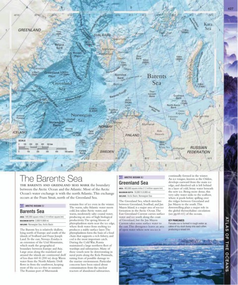
A B C D E F 427
40˚W 30˚W 70˚N 20˚W 10˚W 0˚ 10˚E 20˚E 30˚E 40˚E 50˚E 60˚E 70˚N 70˚E 80˚E
Yermak Plateau Anna Trough Kara
Lena Trough
Syvataya
1 GREENLAND Litke Trough 170m Sea 1
15m (558ft)
(49ft) Spitsbergen Kvitøya Franz Josef
SVALBARD Land
Nordaustlandet
Fracture Zone
5,601m limit of summer pack ice
Belgica (18,377ft)
Bank Fracture Zone Spitsbergen
Hovgaard
Boreas Longyearbyen Barentsøya
Plain Edgeøya Bank 102m (358ft)
Stor
109m
Knipovich Ridge (108ft) (335ft) East Novaya Zemlya Trough
33m
2 Daneborg Storfjordrenna Hopen 2
210m Greenland 3,900m Novaya Zemlya
(689ft) (12,796ft) Bjornöya
limit of winter pack ice
Plain Barents
Bank
Greenland Fracture Zone
Greenland Bjørnoya Sea 328m
(1,076ft)
Sea
Ittoqqortoormiit Barents Trough Iversen Gusinaya Kara Strait 60˚N
Thor
60˚N
Bank
Kolbeinsey Ridge Mohns Ridge (843ft) Bank (154ft)
257m
47m
Jan Mayen
3 North North Kanin 60˚E 3
Jan Mayen Fracture Zone
2,580m Cape Murmansk Bank
(8,465ft) Fugløya Rise Kolguyev
Ostrov
Bank
Jan Mayen Ridge Norwegian Plain NORWAY Tromsø Murmansk Cheshskaya Guba Pechora Arctic Circle
Iceland Norwegian Hammerfest Poluostrov Nar’yan-Mar
Plateau Dumshaf Sea Kanin
Arctic Circle
Basin
Voring
Røst
ICELAND Plateau 1,280m Bank Kola
(4,200ft) Vestfjorden FINLAND Peninsula
SCALE 222m Bodø
4 (738ft) 26m 4
0 100 200 300 400 500 km (85ft)
White Sea RUSSIAN
Archangel
Halten
0 100 200 300 400 500 miles SWEDEN FEDERATION
Bank Gulf of Bothnia Northern Dvina
10˚W 0˚ 10˚E 20˚E 30˚E 40˚E 50˚E
A B C D E F
The Barents Sea ARCTIC OCEAN B2 continually formed in the winter.
An ice tongue, known as the Odden,
THE BARENTS AND GREENLAND SEAS MARK the boundary Greenland Sea develops eastward from the main ice
edge, and dissolved salt is left behind
between the Arctic Ocean and the Atlantic. Most of the Arctic AREA 463,000 square miles (1.2 million square km) in a layer of cold, briny water beneath
the new ice. Being more dense, this
Ocean’s water exchange is with the north Atlantic. This exchange MAXIMUM DEPTH 16,000 ft (4,800 m)
INFLOWS Arctic Basin, Norwegian Sea very salty water sinks to the seafloor,
occurs at the Fram Strait, north of the Greenland Sea. where it pools before spilling over
The Greenland Sea, which stretches the ridges between Greenland and
remains free of ice even in the winter. between Greenland, Svarlbad, and Jan Jan Mayen to the south. This
ARCTIC OCEAN E2
The warm, salty Atlantic water meets Mayen Island, is a major area of sea-ice downwelling plays a major role in
Barents Sea cold, less saline Arctic water, and formation in the Arctic Ocean. The the global thermohaline circulation
warm, moderately salty coastal water, East Greenland Current carries surface (see pp.60-61) of the oceans.
AREA 540,000 square miles (1.4 million square km) producing an area of high biological water and ice south along the coast
MAXIMUM DEPTH 2,000 ft (600 m) productivity. The spring bloom of of Greenland, but the Jan Mayen ICY PANCAKES
phytoplankton starts near the ice edge, Current takes some surface water to Pancake ice is formed in rough water as
INFLOWS Norwegian Sea, Arctic Basin
where fresh water from melting ice the east. This divergence leaves an area cakes of icy slush bump into each other,
The Barents Sea is relatively shallow, produces a stable surface layer. The of open water where new sea ice is producing a raised rim.
lying north of Europe and south of the phytoplankton form the basis of a food
islands of Svalbard and Franz Joseph chain that supports a rich fishery, and
Land. To the east, Novaya Zemlya is cod is the most important catch.
an extension of the Ural Mountains, During the Cold War, Russia
which mark the geographical maintained a large northern fleet of ATLAS OF THE OCEANS
boundary between Europe and Asia. warships and submarines. Many of
Large areas along the mainland and these vessels now lie deteriorating in
around the islands are continental shelf naval ports along the Kola Peninsula,
of less than 660 ft (200 m) deep. Warm raising fears of possible damage to
water from the North Atlantic Drift the marine environment. Particular
flows in from the southwest, keeping concerns have been raised about
most of the sea ice-free in summer. contamination from the nuclear
The Russian port of Murmansk reactors of abandoned submarines.