
Page 424 - (DK) Ocean - The Definitive Visual Guide
P. 424
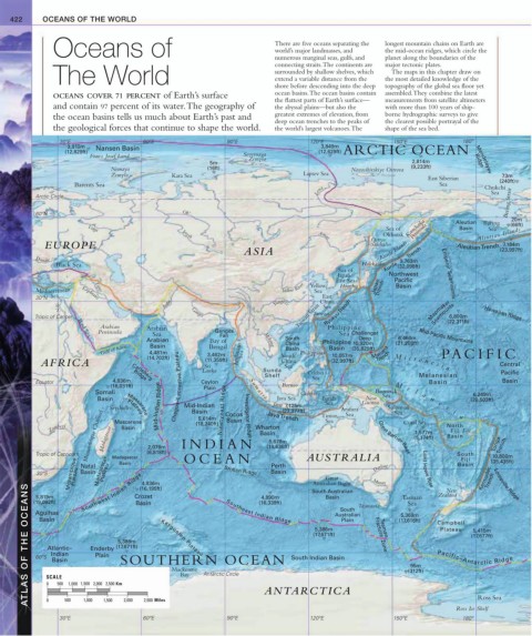
422 OCEANS OF THE WORLD
Oceans of There are five oceans separating the longest mountain chains on Earth are
world’s major landmasses, and
the mid-ocean ridges, which circle the
numerous marginal seas, gulfs, and
connecting straits. The continents are planet along the boundaries of the
major tectonic plates.
The World surrounded by shallow shelves, which the most detailed knowledge of the
The maps in this chapter draw on
extend a variable distance from the
shore before descending into the deep topography of the global sea floor yet
OCEANS COVER 71 PERCENT of Earth’s surface ocean basins. The ocean basins contain assembled. They combine the latest
the flattest parts of Earth’s surface— measurements from satellite altimeters
and contain 97 percent of its water. The geography of the abyssal plains—but also the with more than 100 years of ship-
the ocean basins tells us much about Earth’s past and greatest extremes of elevation, from borne hydrographic surveys to give
deep ocean trenches to the peaks of the clearest possible portrayal of the
the geological forces that continue to shape the world. the world’s largest volcanoes. The shape of the sea bed.
30ºE 60ºE 90ºE 120ºE 150ºE 180º
3,910m Nansen Basin (12,629ft)ARCTIC OCEAN
3,849m
(12,829ft)
Franz Josef Land Severnaya
Zemyla Mendeleyev
5m 2,814m Ridge
Nemaya (16ft) Novosibirskiye Ostrova (9,233ft)
Zemyla Kara Sea Laptev Sea 73m
East Siberian (240ft)
Barents Sea Sea Chukchi
Lena Sea
Bering Strait
Arctic Circle
60ºN Ob’ 20m
Okhotsk Kamchatka Aleutian Bering (66ft)
Basin
Sea
Volga Irtysh Sea of Peninsula Aleutian Islands
EUROPE Amur Ostrov Aleutian Trench 7,184m
Sakhalin
ASIA Kurile Islands (23,997ft)
Danube Kurile Trench
9,763m
Black Sea Hokkaido (32,098ft)
Sea of
Japan/ Northwest Emperor Seamounts
East Sea Pacific
Yellow River Yellow Honshu Japan Basin
Mediterranean Sea Trench
Tigris
Sea Euphrates East
30ºN China
Nile Indus Yangtze Sea Mapmaker
Taiwan
Tropic of Cancer Ganges Taiwan Strait Ryukyu Trench Seamounts 6,800m Hawaiian Ridge
(22,311ft)
Arabian Arabian Philippine
Peninsula Sea Ganges Sea Challenger Mid-Pacific Mountains
Fan
Red Sea
6,464m
Deep
Arabian Bay of Mekong South Philippine 10,920m (21,208ft)
China
Basin
Gulf of Aden 4,481m 3,462m Andaman Sea Basin Philippines Basin (35,829ft) Mariana PA CIFIC
Bengal
10,057m
AFRICA (14,702ft) Sri Sunda South (32,997ft) Trench M i c r o n e s i a Central
(11,359ft)
China
Sea
Lanka
Sea
Ridge
Basin
Basin
Equator 4,836m Carlsberg Ceylon Shelf Celebes Melanesian Pacific
(16,031ft) Chagos–Laccadive Plateau Plain S u m a t r a Borneo M e
(18,240ft) etyeast Ridge
Somali Celebes Bismarck l a 6,249m
Sea
New
Basin Java Sea Banda Guinea n e (20,503ft)
Sea
Java
7,125m
Seychelles Mid-Indian Ridge Mid-Indian Cocos Investigator Ridge Java Trench Timor Arafura Solomon s i a
(23,377ft)
Basin
Mozambique Channel Madagascar INDIAN Basin Great Barrier Reef (5,174ft) Basin Tonga
Sea
Sea
Plateau
Mascarene
Zambezi Mascarene 5,614m Nin Basin Wharton Sea Coral Sea North
Basin
Fiji Fiji
1,577m
Trench
5,678m
2,078m
Tropic of Capricorn Madagascar (6,818ft) OCEAN (18,636ft) AUSTRALIA South (35,435ft)
10,800m
Mozambique Plateau Southwest Indian Ridge Basin (16,339ft) South Australian Tasmania Tasman Zealand Kermadec Trench Louisville Ridge
Fiji
Basin
Natal
Basin
30ºS Basin Madagascar Plateau Broken Ridge Perth Darling Lord Howe Rise Basin
Great
Murray
4,936m
Australian Bight
ATLAS OF THE OCEANS Agulhas Enderby (17,671ft) Kerguelen Plateau Antarctic Circle South Indian Basin Plain Fracture Zone (17,616ft) Campbell (17,677ft)
(16,195ft)
New
Crozet
5,819m
4,890m
Basin
(19,092ft)
Sea
South
Australian
5,369m
Basin
Southeast Indian Ridge
Plateau
5,386m
5,415m
(17,671ft)
Tasman
5,386m
Atlantic–
Indian
Plain
SOUTHERN OCEAN
60ºS
Pacific–Antarctic Ridge
Basin
95m
Mackenzie
(312ft)
Bay
SCALE
1,000 1,500 2,000 2,500
500
Km
0
ANTARCTICA
Ross Sea
500
Miles
1,000
0
2,500
2,000
1,500
Ross Ice Shelf
30ºE 60ºE 90ºE 120ºE 150ºE 180º