
Page 452 - (DK) Ocean - The Definitive Visual Guide
P. 452
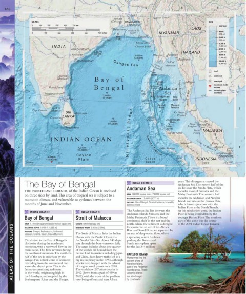
450 A B C D E F
80˚E 90˚E 100˚E
Kolkata Ganges Tropic of Cancer
SCALE (Calcutta) BANGLADESH KEY
0 150 300 450 600 750 km Chittagong sea level
Baleshwar LAOS
1 Mouths of the 20˚N 800 ft 1
0 150 300 450 600 750 miles Ganges MYANMAR (250 m)
35m Sittwe 1,600 ft
Puri (115ft) Irrawaddy Salween (500 m)
Ramree Island 3,300 ft
INDIA Cheduba Island (1,000 m)
Godavari
Visakhapatnam 6,500 ft
2,807m THAILAND (2,000 m)
Kakinada (9,210ft) 2,429m Bassein Rangoon 9,800 ft
(7,970ft) (3,000 m)
Krishna
Machilipatnam Moulmein 16,400 ft
Gulf of
(5,000 m)
G a n g e s F a n
Martaban
Mouths of
2 the Irrawaddy land 2
Coromandel Coast Ba y of Alcock Mergui sea depth
18m
Chennai (59ft) seamount
(Madras)
Rise
Pondicherry Bengal Andaman Andaman maximum depth
on map
Islands
10˚N Mergui Archipelago tectonic plate
Port
Nagappattinam 3,462m Blair Bank Invisible Sea boundary
Palk Strait (11,359ft) Andaman Bank Isthmus of Kra 10˚N
Roe
Jaffna
Basin
Toticorin Ten Degree
Channel
Sewell Mergui
3 Gulf of Rise Terrace 3
Cape Comorin Mannar e Krabi
SRI Batticaloa g Ko Phuket
LANKA d Phuket
Colombo Nicobar
i Islands Dreadnought
3,462m Bank
Galle (11,359ft) R Pulau
241m Langkawi George
Dondra Head t (791ft) Town
s Pulau MALAYSIA
a Banda Aceh Pinang Ma l ay P e ni ns u la
INDIAN OCEAN y e
Klang
t S u n d a Tr e n ch Belawan Strait of Malacca
4 4,217m e Pulau Simeulue Melaka Johor 4
(13,836ft) n S u m a t r a Bahru
i Singapore
Ceylon N
4,846m SINGAPORE
(15,900ft) Plain Cocos Pulau INDONESIA
Equator Basin Nias Equator
80˚E 90˚E 100˚E
A B C D E F
The Bay of Bengal INDIAN OCEAN E3 years. This divergence created the
Andaman Sea. The eastern half of the
THE NORTHEAST CORNER of the Indian Ocean is enclosed Andaman Sea sea lies over the Sunda Plate, which
includes most of Sumatra and the
on three sides by land. This area of tropical sea is subject to a AREA 308,000 square miles (798,000 square km) Malay Peninsula. The western half
includes the Andaman and Nicobar
monsoon climate, and vulnerable to cyclones between the MAXIMUM DEPTH 12,400 ft (3,777 m)
INFLOWS Bay of Bengal, Strait of Malacca; Irriwaddy, Islands and sits on the Burma Plate,
months of June and November. Salween rivers which forms a junction with the
Indian Plate at the Sunda Trench.
The Andaman Sea lies between the At this subduction zone, the Indian
INDIAN OCEAN C2 INDIAN OCEAN F4
Andaman Islands, Sumatra, and the Plate is being overridden by the
Bay of Bengal Strait of Malacca Malay Peninsula. There is a broad younger Burma Plate. The southern
continental shelf in the east and the part of this zone was the source
of the 2004 Indian Ocean tsunami.
north, where the sediment is dredged
AREA 1.1 million square miles (2.9 million square km)
LENGTH 600 miles (963 km)
ATLAS OF THE OCEANS Circulation in the Bay of Bengal is Ocean with the Pacific Ocean, via a spreading center has been
for cassiterite, an ore of tin. Alcock
MAXIMUM DEPTH 15,400 ft (4,695 m)
MINIMUM WIDTH 9 miles (15 km)
Rise and Sewell Rise are separated by
INFLOWS Ganges, Brahmapurta, Mahanadi,
The Strait of Malacca links the Indian
an area of deep ocean floor, where
Godavari, Krishna, Kaveri, Irrawaddy rivers
the South China Sea. About 140 ships
pushing the Burma and
pass through this busy waterway daily.
Sunda microplates apart
clockwise during the northwest
monsoon, with a westward flow in the
The cargo includes about one quarter
for the last 3–4 million
of the world’s oil, headed from the
main ocean. This flow reverses during
Persian Gulf to markets including Japan
the southwest monsoon. The northern
HAVELOCK ISLAND
and China. Such heavy traffic led to a
half of the bay is underlain by the
Mangroves line the
Ganges Fan, a thick cone of sediment
big rise in piracy in the 1990s, although
eastern shore of
attacks have dropped with the advent
extending from the continental rise
Havelock Island,
across the abyssal plain. This is the
of tougher naval patrols since 2005.
part of the Andaman
The world saw 297 pirate attacks in
fastest-accumulating sediment
Islands group. These
in the world, originating high in
2012 (down from a peak of 439 in
volcanic islands
2011), with the worst of the problem
the Himalayas, and supplied by the
are also fringed
by coral reefs.
Brahmaputra River and the Ganges.
now being off east and west Africa.