
Page 448 - (DK) Ocean - The Definitive Visual Guide
P. 448
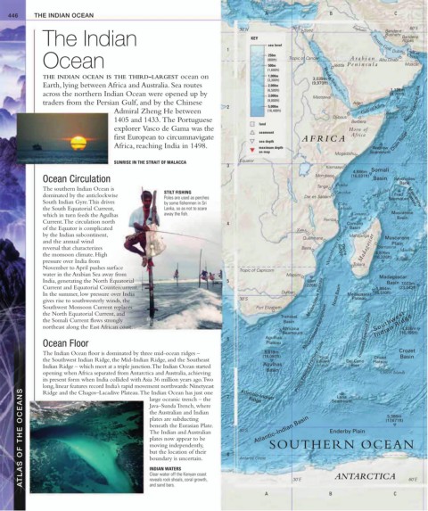
446 THE INDIAN OCEAN A B C
30˚N 30˚E Suez Euphrates Bander-e 60˚E
The Indian KEY Persian Gulf Bander-e
Bushehr
Abbas
1 sea level Dubai Gulf of
Ocean (800ft) Tropic of Cancer Jedda Peninsula Abu Dhabi Muscat
250m
Oman
Ar abian
500m
(1,600ft)
THE INDIAN OCEAN IS THE THIRD-LARGEST ocean on 1,000m Red Sea
(3,300ft) 3,039m
Earth, lying between Africa and Australia. Sea routes 2,000m (9,970ft)
(6,500ft) 1,128m
across the northern Indian Ocean were opened up by (3.701ft)
3,000m
Massawa
traders from the Persian Gulf, and by the Chinese (9,800ft) Aden Owen Fracture Zone
2 5,000m Socotra
Admiral Zheng He between (16,400ft) Gulf of Aden Raas
1405 and 1433. The Portuguese Djibouti Berbera Caseyr
land
explorer Vasco de Gama was the Horn of
seamount
first European to circumnavigate AFRICA Africa
sea depth Chain Ridge
Africa, reaching India in 1498. maximum depth Andrew
on map Seamount
Mogadishu
Equator
SUNRISE IN THE STRAIT OF MALACCA
3 Kismaayo
4,886m Somali
Ocean Circulation Mombasa (16,031ft) Basin Seychelles
Tanga Pemba Bank
The southern Indian Ocean is
STILT FISHING Zanzibar Seychelles
dominated by the anticlockwise Fred
Poles are used as perches Dar es Salaam Seamount Mascarene
South Indian Gyre. This drives by some fishermen in Sri Cabo Plateau
the South Equatorial Current, Lanka, so as not to scare Delgado
which in turn feeds the Agulhas away the fish. Comoros Mascarene
Basin
Current. The circulation north 4 Pemba Comoro
of the Equator is complicated Basin
by the Indian subcontinent, Zambezi Mahajanga
Quelimane Mascarene
and the annual wind Plain
reversal that characterizes Beira Mozambique Channel Madagascar Toamasina Mauritius
4,976m
the monsoon climate. High (16,326ft)
Ridge
Davie
pressure over India from Toliara Réunion
November to April pushes surface
Tropic of Capricorn
water in the Arabian Sea away from Maputo Madagascar
India, generating the North Equatorial 5 69m Basin 7,023m
Current and Equatorial Countercurrent. (226ft) 1,984m (23,042ft)
In the summer, low pressure over India Durban Mozambique Plateau Natal Basin Madagascar (6,510ft)
gives rise to southwesterly winds, the 30˚S Plateau
Southwest Monsoon Current replaces Port Elizabeth
the North Equatorial Current, and
Transkei
the Somali Current flows strongly Basin Southwest
northeast along the East African coast. Africana Mozambique Escarpment Indian Ridge
4,936m
Seamount Indomed Fracture Zone (16,195ft)
6 Agulhas
Ocean Floor Plateau
The Indian Ocean floor is dominated by three mid-ocean ridges – 5,819m Crozet
(19,092ft) Prince Crozet Basin
the Southwest Indian Ridge, the Mid-Indian Ridge, and the Southeast Edward Del Cano Plateau
Islands
Indian Ridge – which meet at a triple junction. The Indian Ocean started Agulhas Prince Edward Fracture Zone Rise
opening when Africa separated from Antarctica and Australia, achieving Basin Crozet Islands
its present form when India collided with Asia 36 million years ago. Two
long, linear features record India’s rapid movement northwards: Ninetyeast 7 Atlantic–Indian Seamount
ATLAS OF THE OCEANS the Australian and Indian 8 60˚S Atlantic–Indian Basin Enderby Plain (17,671ft)
Ridge and the Chagos–Lacadive Plateau. The Indian Ocean has just one
Lena
large oceanic trench – the
Ridge
Java–Sunda Trench, where
5,386m
plates are subducting
beneath the Eurasian Plate.
The Indian and Australian
plates now appear to be
SOUTHERN OCEAN
moving independently,
but the location of their
boundary is uncertain.
Antartic Circle
INDIAN WATERS
Clear water off the Kenyan coast
reveals rock shoals, coral growth,
and sand bars.
A 30˚E B ANTARCTICA C 60˚E