
Page 447 - (DK) Ocean - The Definitive Visual Guide
P. 447
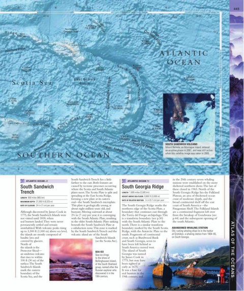
G                     H                     I                    J                     K                     L                 445


                           40˚W                                      30˚W                              50˚S         20˚W

                                                   1,608m   South
                                                   (5,276ft)
                                       Northwest
                                      Georgia Rise                                                                                  1
                                                       Georgia Rise
      R i d g e                                                                                                               50˚S
            110m                                                                          Islas
            (361ft)                                                                  Orcadas Rise
                                                                                    1,748m
                                                                                    (5,735ft)
                                           South Georgia
       Fracture Zone                                                                          ATLANTIC
                                                                                                   OCEAN
                                                                               8,325m
              4,314m                                     1,077m                (27,314ft)
             (14,154ft)                                  (3,534ft)                                                                  2
                                                                                                              3,099m
                                                                 East Scotia  Ridge
                                            East Scotia                                                      (10,168ft)
        Scotia Sea                             Basin                 South Sandwich Trench


      1,139m
     (3,737ft)                                                           South Sandwich Islands
                                         Guevara
                                        Seamounts                   3,140m
                5,576m                                             (10,302ft)              5,404m                                   3
               (18,295ft)                                                                  (17,731ft)
                                                   210m
                                   B r u c e     R i d g e
                                                   (689ft)
     South Orkney Islands
                                                                                          1,780m
                     Orkney Deep                                                          (5,840ft)
        187m
                                                                        7,152m
        (614ft)                                                        (23,466ft)           60˚S
                     Endurance  Ridge                        Ligeti Ridge     South Sandwich      SOUTH SANDWICH VOLCANO            4
                                                                                                  Mount Belinda, on Montague Island, entered
                                                                               Fracture Zone
           SOUTHERN OCEAN                                                                         an eruptive phase in 2001, and was still active
                                                                                                  when this satellite image was taken in 2005.
                      40˚W                             30˚W                              20˚W                               10˚W

           G                     H                     I                    J                     K                     L

                                           South Sandwich Trench lies a little                        in the 20th century seven whaling
                ATLANTIC OCEAN J2                                           ATLANTIC OCEAN F3
                                           farther to the east. Both features are                     stations were established on the more
             South Sandwich                caused by tectonic processes occurring   South Georgia Ridge  sheltered northern shore. The last of
                                           where the Scotia and South Atlantic                        these closed in 1965. North of the
             Trench                        plates meet. The Scotia Plate is split and   LENGTH  1,600 miles (2,500 km)  South Georgia Ridge lies the Falkland
                                           spreading at the East Scotia Ridge,   HEIGHT ABOVE SEA FLOOR  9,800 ft (3,000 m)  Plateau, an area of thickened ocean
             LENGTH  600 miles (965 km)
                                           forming a new plate at its eastern   RATE OF RELATIVE MOTION   ¼ in (0.7 cm) per year  crust of moderate depth, and the
             MAXIMUM DEPTH  27,300 ft (8,325 m)  end—the South Sandwich microplate.                   broad continental shelf off the east
             RATE OF CLOSURE  2¾ in (7 cm) per year  This plate is geologically young, at   The South Georgia Ridge marks the   coast of South America—the
                                           about eight million years old, and   northern edge of the Scotia Plate, a   Patagonian Shelf. The Falkland Islands
             Although discovered by James Cook in   buoyant. Moving eastward at about   boundary that continues east through   are a continental fragment left over
             1775, the South Sandwich Islands were   2¾ in (7 cm) per year, it is converging   the Tierra del Fuego archipelago. This   from the breakup of Gondwana (see
             not visited until 1818, when    with the South Atlantic Plate, resulting   is a transform boundary (see p.50)   p.44) and the subsequent opening of
             seal hunters landed. They were never   in the older South Atlantic Plate sinking  with the South Atlantic Plate to the   the south Atlantic.
             permanently settled and remain   beneath the South Sandwich Plate at    north. There is a similar transform
             uninhabited. With volcanic peaks rising   a subduction zone. This zone is marked   boundary marked by the South Scotia   ABANDONED WHALING STATION
             up to 3,300 ft (1,000 m) above sea level,   by the South Sandwich Trench and the   Ridge, with the Antarctic Plate to the   Old, rusting whaling ships lie in the harbor
             the islands are mostly composed of   volcanic island arc of the South   south. Fragments of continental   at Grytviken, a whaling station from 1904–65,
             basaltic lava and                           Sandwich Islands   crust, such as Burdwood Bank   on South Georgia.
             covered by glaciers.                        (or the Scotia Arc).  and South Georgia, seem to
             North of                                                   have been left behind as
             the islands is the                                         South America moved west.
             Protector Shoal—                            SEA ICE        The island of South                                              ATLAS OF THE OCEANS
             an undersea volcano                                        Georgia was named
                                                         Sea ice clings
             that rises to within                        to the shore of   by James Cook in
             100 ft (30 m) of the                        Bellinghausen Island,   1775, but may have
             surface. The South                          of the South Shetland   been sighted as
             Sandwich Islands                            group, named after the   early as 1675.
             mark the eastern                            Russian explorer who   It was a base for
             boundary of the                             discovered it in the   seal hunters in the
             Scotia Sea, and the                         19th century.  19th century, and