
Page 451 - (DK) Ocean - The Definitive Visual Guide
P. 451
D E F G H I 449
50˚E 60˚E 70˚E 80˚E
SCALE
0 100 200 300 400 500 km
AFGHANISTAN 1
0 100 200 300 400 500 miles
30˚N
IRAN
Bandar-e Bushehr
2
PAKISTAN
Bandar-e `Abbas
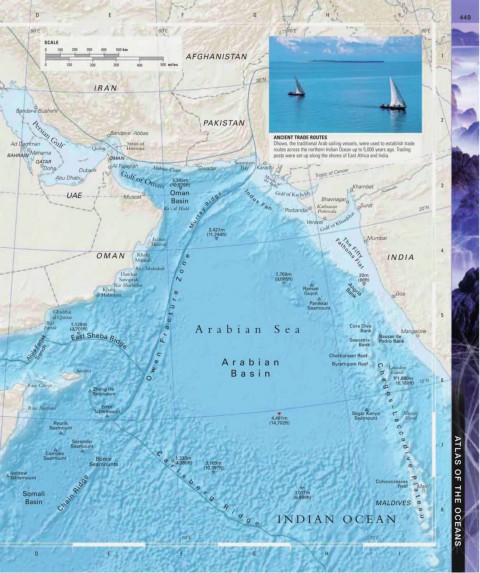
ANCIENT TRADE ROUTES
Ad Damman Strait of Dhows, the traditional Arab sailing vessels, were used to establish trade
Persian Gulf
Qeshm Hormuz routes across the northern Indian Ocean up to 5,000 years ago. Trading
Manama
BAHRAIN posts were set up along the shores of East Africa and India.
OMAN
QATAR Sonmiani
Al Fujayrah
Doha Dubai Makran Coast Gwadar Bay Karachi Indus Tropic of Cancer
Abu Dhabi Gulf of Oman
3,345m Mouths of
(10,975ft) the Indus Khambat Narmada 3
Oman Gulf of Kachchh
M u r r a y R i d g e Porbandar Peninsula
UAE Muscat
Basin I n d u s F a n Bhavnagar
Ra’s al Hadd Kathiawar Surat 20˚N
3,427m Veraval Gulf of Khambhat
(11,244ft)
Jazirat Mumbai
Masirah
4
OMAN Khalij e Fathoms Flat INDIA
The Fifty
Masirah
n
Ra’s Madrakah
Dawhat o 2,769m 20m
Sawqirah Z (9,085ft) (66ft)
Ras Sharbithat
Khalij Raman Angria
al Halaniyat e Guyot Bank Goa
r
Panikkar
u Seamount
Ghubbat t
al Qamar 5
Ra’s 1,128m c
Fartak (3,701ft) r a Arabian Sea Cora Diva Bassas de Mangalore
Bank
Alula-Fartak East Sheba Ridge n F Cherbaniani Reef Pedro Bank
Sesostris
Bank
Trench
Socotra w e Arabian Byramgore Reef C Laccadive
Basin
Islands
h
O a 1,880m 6
Raas Caseyr g (6,168ft) 10˚N
Zheng He
Seamount o
s
Raas Xaafuun Error –
Tablemount
Sagar Kanya L Minicoy
4,481m Seamount a Island
Ryurik (14,702ft)
Seamount c
c
Serendip a
Seamount d 7
Camões C i
Seamount Bunce a 1,333m v
Seamounts (4,380ft) 3,169m e
r
(10,397ft)
l
Andrew
Chain Ridge e r 3,017m Reef a ATLAS OF THE OCEANS
Tablemount s b Colvocoresses P
l
Male’
Somali g (9,899ft) t
Basin MALDIVES e
R
i a 8
d u
g INDIAN OCEAN
e
60˚E 70˚E
D E F G H I