
Page 466 - (DK) Ocean - The Definitive Visual Guide
P. 466
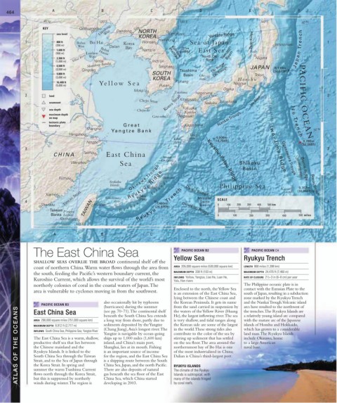
464 A B C D E F
40˚N 120˚E 130˚E 140˚E 40˚N
Liaodong Dandong NORTH
KEY Qinhuangdao Yalu
sea level Wan Kimch’aek
KOREA Yamato Ridge
Hamhung Sado Ridge Tr e n c h
1 800 ft Bohai Bo Hai Korea Wonsan Sea of Japan/ 1
(250 m) Wan Dalian Bay Ishinomaki
21m
1,600 ft Bohai Namp’o Korean (69ft) East Sea Sado
(500 m) Laizhou Haixia Plateau Yamato Basin
3,300 ft Yellow River Wan North Oki Niigata J a p a n
Bank
(1,000 m) Yantai Inch’on
Shandong Bandai
6,500 ft Tonghae Oki Ridge JAPAN
8,130m
(2,000 m) Qingdao Tsushima Oki Trough (26,673ft)
9,800 ft SOUTH Basin Oki- Tokyo
(3,000 m) KOREA shoto Honshu
16,400 ft Yello w Sea P‘ohang Nagoya
(5,000 m) Pusan
Mokp’o Osaka
Tsushima Hiroshima
2 land Inland Sea 2
seamount Da Yunhe Cheju Strait Korea Strait Kitakyushu Shikoku Tokushima Izu Spur PACIFIC OCEAN
sea depth Cheju-do Fukuoka I
z
Kyushu I z u - s h o t o u
maximum depth Nagasaki
on map Yangtze Goto-retto Nankai Trough T r
tectonic plate
boundary Great Kagoshima e
Shanghai n 30˚N
Yangtz e Bank I w o –
Hangzhou Tanega- c h
30˚N 4,506m
Yaku- shima
Ningbo shima (14,784ft) 9,780m
(32,088ft)
3 3
CHINA Taizhou East China Amami- J i m a R i d g e
O-shima Kyushu–Palau Ridge Ogasawara Trough
Wenzhou Sea Shikoku Ogasawara-shoto Bonin Ridge
Basin
Fuzhou O k i n a w a Tr o u g h Okinawa
Senkaku s
Islands R y u k y u R i d g e a n d Philippine Sea Kazan- 9,157m Bonin Trench
Naha
l
Xiamen Sakishima- 24m I s 7,460m Tr e n c h Daito Ridge retto (30,044ft)
Daito
4 Taiwan Strait shoto (79ft) Minami SCALE 4
Shantou Hualien R y u k y u (24,476ft) Basin 0 100 200 300 400 500 km
Taiwan TAIWAN Okidaito Ridge
P’enghu R y u k y u
Banks Liehtao 0 100 200 300 400 500 miles
Kaohsiung
120˚E 130˚E 140˚E
A B C D E F
The East China Sea PACIFIC OCEAN B2 PACIFIC OCEAN C4
SHALLOW SEAS OVERLIE THE BROAD continental shelf off the Yellow Sea Ryukyu Trench
coast of northern China. Warm water flows through the area from AREA 205,000 square miles (530,000 square km) LENGTH 868 miles (1,398 km)
the south, feeding the Pacific’s western boundary current, the MAXIMUM DEPTH 338 ft (103 m) MAXIMUM DEPTH 24,476 ft (7,460 m)
1
INFLOWS Yellow, Yangtze, Liao He, Luan He, RATE OF CLOSURE 2 / 2–3 in (6–8 cm) per year
Kuroshio Current, which allows the survival of the world’s most Yalu, Han rivers
northerly colonies of coral in the coastal waters of Japan. The The Philippine oceanic plate is in
Enclosed to the north, the Yellow Sea contact with the Eurasian Plate to the
area is vulnerable to cyclones moving in from the southwest.
is an extension of the East China Sea, south of Japan, resulting in a subduction
lying between the Chinese coast and zone marked by the Ryukyu Trench
also occasionally hit by typhoons the Korean Peninsula. It gets its name and the Nankai Trough. Volcanic island
PACIFIC OCEAN B3 (hurricanes) during the summer from the sand carried in suspension by arcs have resulted to the northwest of
ATLAS OF THE OCEANS MAXIMUM DEPTH 8,912 ft (2,717 m) (Chang Jiang), Asia’s longest river. The in the world. These strong tides also which has grown to a considerable
(see pp. 70–71). The continental shelf
the waters of the Yellow River (Huang
East China Sea
the trenches. The Ryukyu Islands are
a relatively young island arc compared
He), the largest inflowing river. The sea
beneath the South China Sea extends
AREA 290,000 square miles (751,000 square km)
with the mature arc of the Japanese
is very shallow, and tidal ranges along
a long way from shore, partly due to
islands of Honshu and Hokkaido,
the Korean side are some of the largest
sediments deposited by the Yangtze
INFLOWS South China Sea, Philippine Sea, Yangtze River
Yangtze is navigable by ocean-going
contribute to the color of the sea by
land mass. The Ryukyu Islands
stirring up sediment that has settled
The East China Sea is a warm, shallow, ships up to 1,000 miles (1,600 km)
include Okinawa, home
on the sea floor. The area around the
productive shelf sea that lies between
inland, and China’s main port,
to a large American
the Chinese mainland and the
northernmost bay of Bo Hai is one
naval base.
Shanghai, lies at its mouth. Fishing
is an important source of income
Ryukyu Islands. It is linked to the
of the most industrialized in China;
South China Sea through the Taiwan
for the region, and the East China Sea
Dalian is China’s third-largest port.
Strait, and to the Sea of Japan through
is a shipping route between the South
China Sea, Japan, and the north Pacific.
the Korea Strait. In spring and
RYUKYU ISLANDS
There are also deposits of natural
summer the warm Tsushima Current
The climate of the Ryukyu
gas beneath the sea floor of the East
flows north through the Korea Strait,
Islands is subtropical, with
China Sea, which China started
but this is suppressed by northerly
many of the islands fringed
winds during winter. The region is
developing in 2003.
by coral reefs.