
Page 465 - (DK) Ocean - The Definitive Visual Guide
P. 465
463
Tohuku Tsunami
The undersea earthquake and consequent tsunami
STORY OF THE TSUNAMI
that hit Japan’s Tohuku region (the northeast part of
Honshu, Japan’s largest island) on March 11, 2011, is EARTHQUAKE HITS HONSHU
one of the greatest disasters in human terms ever to The magnitude 9.0 earthquake,
at around 2:45 pm local time,
hit Japan, and financially the costliest natural disaster caused severe damage to roads
ever. As of January 2014, it is reported that the and buildings in Tohuku and
some areas surrounding Tokyo.
catastrophe killed 15,883 people, with 2,640 missing, It also set two oil refineries on fire.
and has had an estimated economic cost of US$235
billion. In addition, it has had serious environmental
results, due to breakdowns, explosions, and leaks
caused at the Fukushima nuclear energy plant.
The tsunami resulted from a sudden fracture in TSUNAMI WAVES APPEAR
Earth’s crust along a fault under the sea floor Within a few minutes, media
reports and film footage were
approximately 43 miles (70 km) off Honshu. This showing massive tsunami
rupture triggered a massive earthquake. As sections waves sweeping relentlessly
toward the coast of the
of the sea floor suddenly sprang upward by around
Tohuku region.
20–27 ft (6-8 m), powerful tsunami waves were
generated. On reaching the coast, these swept WARNINGS GO OUT
through towns and across fields, roads, and airports, In Japan’s coastal areas,
sirens warn of any approaching
smashing dwellings, vehicles, and boats. When the
tsunami, and signs indicate to
water later receded, a colossal jumble of debris was where people should evacuate.
dumped on the landscape. PRELUDE But this time, the waves were
so big that the warnings
Within days, it was apparent that tens of thousands had a limited impact.
of buildings had been destroyed and hundreds of
thousands of people displaced. At the Fukushima
plant, three reactors suffered overheating and
gas explosions after damage to backup power and
containment systems. Subsequently, there were leaks
of harmful radioactive materials from the plant into
the atmosphere, ocean, and ground around the plant.
TSUNAMI SURGE Within
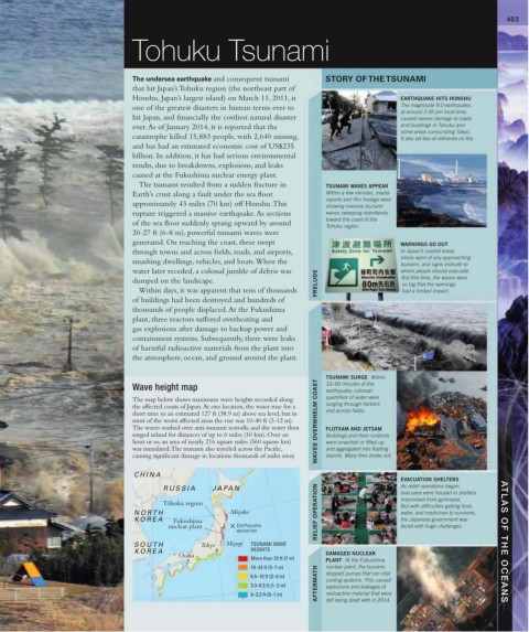
Wave height map 10–50 minutes of the
earthquake, colossal
The map below shows maximum wave heights recorded along quantities of water were
the affected coasts of Japan. At one location, the water rose for a surging through harbors
short time to an estimated 127 ft (38.9 m) above sea level, but in and across fields.
most of the worst affected areas the rise was 10-40 ft (3-12 m). WAVES OVERWHELM COAST
The waves washed over anti-tsunami seawalls, and the water then FLOTSAM AND JETSAM
surged inland for distances of up to 6 miles (10 km). Over an Buildings and their contents
hour or so, an area of nearly 216 square miles (560 square km) were smashed or lifted up
was inundated. The tsunami also traveled across the Pacific, and aggregated into floating
causing significant damage in locations thousands of miles away. islands. Many fires broke out.
CHINA
EVACUATION SHELTERS
RUSSIA JA PA N As relief operations began,
evacuees were housed in shelters
To ¯hoku region improvised from gymnasia.
But with difficulties getting food,
NOR TH Miyako RELIEF OPERATION water, and medicines to survivors,
K OREA Fukushima the Japanese government was
nuclear plant Earthquake faced with huge challenges.
epicenter
SOUTH Tokyo Miyagi TSUNAMI WAVE ATLAS OF THE OCEANS
K OREA HEIGHTS DAMAGED NUCLEAR
Osaka
More than 23 ft (7 m) PLANT At the Fukushima
10–23 ft (3–7 m) nuclear plant, the tsunami
AFTERMATH
6.5–10 ft (2–3 m) stopped pumps that ran vital
cooling systems. This caused
3.3–6.5 ft (1–2 m) explosions and leakages of
0–3.3 ft (0–1 m) radioactive material that were
still being dealt with in 2014.