
Page 264 - Inventions - A Visual Encyclopedia (DK - Smithsonian)
P. 264
Watching over Earth
From their orbits high above Earth, dozens of satellites keep watch
over our planet. They range from surveillance satellites photographing
enemy territory to weather satellites providing accurate forecasts and
remote-sensing satellites that use advanced technology to map Earth’s
geology, land use, and changing climate.
SPACE LANDSAT 1 WOW!
Few people guessed how useful it would In 1967, American spy
be to study Earth from space until early satellites monitoring
astronauts reported seeing tiny details nuclear tests discovered
with the unaided eye and space agencies blasts of gamma rays
investigated further. The first satellite from galaxies billions
designed specifically for “remote sensing” of light-years away.
of Earth was NASA’s Landsat 1. Launched
in 1972, it used a camera system and
a multispectral scanner to study Earth’s
landmasses, including their agriculture,
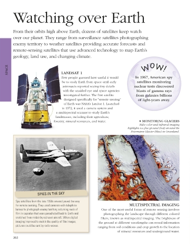
forestry, mineral resources, and water. ▼ MONITORING GLACIERS
False-color and infrared imaging
highlights ice-free ground (red) around the
Petermann Glacier (blue) in Greenland.
SPIES IN THE SKY
Spy satellites from the late 1950s onward paved the way
for remote sensing. They used cameras with telephoto MULTISPECTRAL IMAGING
lenses to photograph enemy territory, returning reels of One of the most useful forms of remote sensing involves
film in capsules that were parachuted back to Earth and photographing the landscape through different colored
snatched from midair by retrieval aircraft. When digital filters, known as multispectral imaging. The brightness of
imaging improved to match the quality of film images, the ground at different wavelengths can reveal information
pictures could be sent by radio waves. ranging from soil conditions and crop growth to the location
of mineral resources and underground water.
262
US_262-263_Remote_sensing_Main.indd 262 08/03/18 3:10 PM