
Page 265 - Inventions - A Visual Encyclopedia (DK - Smithsonian)
P. 265
WEATHER WATCHERS
The first weather satellite, TIROS-1, was launched
in 1960, and by the 1970s, satellites were placed
in high orbits where they could photograph
weather patterns across large areas of Earth.
Today, remote-sensing instruments can monitor
wind speeds, temperature, and other conditions in
the atmosphere and oceans, measuring large-scale
patterns and changes to Earth’s overall climate.
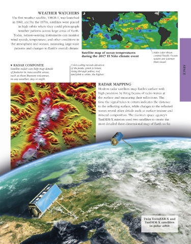
Satellite map of ocean temperatures False color shows
during the 2017 El Niño climate event central Pacific Ocean
waters are warmer
than usual.
▼ RADAR COMPOSITE Color-coding reveals elevation
Satellite radar can help map details of the peaks: green is lowest, SPACE
of features in inaccessible areas, rising through yellow, red,
such as these Russian volcanoes, and pink to white, the highest.
in any weather, day or night.
RADAR MAPPING
Modern radar satellites map Earth’s surface with
high precision by firing beams of radio waves at
the surface and measuring their reflections. The
time the signal takes to return indicates the distance
to the reflecting surface, while changes to the reflected
waves reveal other details such as surface texture and
mineral composition. The German space agency’s
TanDEM-X mission used two satellites to create the
most detailed three-dimensional map of Earth so far.
Twin TerraSAR-X and
TanDEM-X satellites
in polar orbit
US_262-263_Remote_sensing_Main.indd 263 16/03/18 3:41 PM